Cartosat 2B (PSLV-CA launched on July 11, 2010)

Status
Not open for further replies.
Z

Zipi

Guest
cartosat2a_img.gif


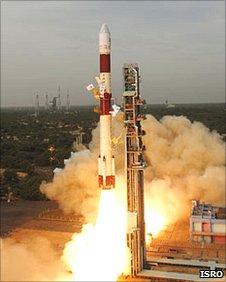
Launch time: 03:53 GMT on 12th (11:53 pm EDT on 11th)
Launch site: Satish Dhawan Space Center, Sriharikota, India

India's Polar Satellite Launch Vehicle (PSLV) will launch the Cartosat 2B remote sensing satellite and multiple secondary payloads. Delayed from May 5. Delayed from May 9 by second stage pressure issue.

Cartosat-2B Wikipedia Article: http://en.wikipedia.org/wiki/Cartosat-2B
ISRO's Cartosat-2A Page: http://www.isro.org/satellites/cartosat2A.aspx

pslv_b.gif


PSLV Launch Vehicle

ISRO's PSLV Page: http://www.isro.org/Launchvehicles/PSLV/pslv.aspx
PSLV Wikipedia Article: http://en.wikipedia.org/wiki/Polar_Sate ... ch_Vehicle
Astronautix PSLV Page: http://www.astronautix.com/lvs/pslv.htm

pslv.jpg


First Stage

One S-138 solid rocket motor burning HTPB

Astronautix PSLV-1 Page: http://www.astronautix.com/engines/pslv1.htm

Boosters

PSLV-CA means "core alone" version and all six strap on boosters are missing from this configuration. There still are two small roll control modules and two first stage motor control injection tanks present.

Second Stage

One L-40 Vikas engine burning N2O4/UDMH[7url]

Vikas Wikipedia Article: [url=http://en.wikipedia.org/wiki/Vikas_engine]http://en.wikipedia.org/wiki/Vikas_engine

Vikas Astronautix Page: http://www.astronautix.com/engines/viking.htm


Third Stage

One S-7 solid rocket motor

PSLV-3 Astronautix Page: http://www.astronautix.com/engines/pslv3.htm


Third and fourth stages attached together at this image

Fourth Stage

Two liquid rocket engines burning N2O4/MMH[7url]

PSLV-4 Astronautix Page: [url=http://www.astronautix.com/engines/pslv4.htm]http://www.astronautix.com/engines/pslv4.htm


Sriharikota - Launch Site

Sriharikota in Wikipedia: http://en.wikipedia.org/wiki/Sriharikota
ISRO's Satish Dhawan Space centre Page: http://www.isro.org/isrocentres/sdsc.aspx
Google Maps Link: http://maps.google.com/maps?f=q&source= ... 5&t=h&z=15

shar_img.gif
 
E

EarthlingX

Guest
news.bbc.co.uk : Norway launches AISSat ship-tracking spacecraft
Page last updated at 11:33 GMT, Monday, 12 July 2010 12:33 UK

By Jonathan Amos
Science correspondent, BBC News

Norway has launched the innovative AISSat-1 spacecraft to monitor shipping in its territorial waters.

The small satellite will track vessels over 300 gross tonnes by picking up the signals from their AIS (Automatic Identification System) transponders.

_48326484_48326485.jpg

The Indian PSLV rocket carried five spacecraft into orbit

"Norway has the largest sea area to manage in Europe, and this area is the source for a lot of Norwegian income, from oil to fisheries," explained Bo Andersen, the director general of the Norwegian Space Centre.


Norway is keen to stress, however, that AISSat-1 will be keeping watch over its national waters only.

"AISSat-1 is a simple demonstrator," Mr Andersen told BBC News on Monday.

"If it works, it will be put into operation and we may launch new ones, also.

The spacecraft's 600km-high polar orbit means it will get sight of Norway's economic zone every 100 minutes.

The 4.4m-euro (35m Kroner; £3.7m) satellite has been funded by the Norwegian Space Centre.

The satellite bus, or chassis, was provided by the University of Toronto, Canada. The payload was developed by Kongsberg Seatex AS in co-operation with the Norwegian Defence Research Establishment (FFI).
 
E

EarthlingX

Guest
www.spacemart.com : Eyes In The Sky Give India Edge In Space
by Staff Writers

Chennai, India (PTI) Jul 14, 2010

With the successful launch of Cartosat-2B on Monday, India has reached a `critical constellation' of 10 active remote sensing satellites in space, which gives it a clear edge in the region for monitoring borders and movements across them.

While mapping and infrastructure development are seen as primary applications of a remote sensing satellite, its use in spying is often underplayed. A combination of four Cartosats (1,2,2A and 2B) hovering 630 km above earth allows India to keep areas under close and prolonged surveillance. Multiple satellites ensure that a particular geographical area can be `revisited' every 48 hours.
 
Status
Not open for further replies.