TanDEM-X (Dnepr launched on June 20, 2010)

Status
Not open for further replies.
Z

Zipi

Guest
Launch time: 02:14 GMT on 21st (10:14 pm EDT on 20th)
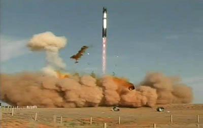
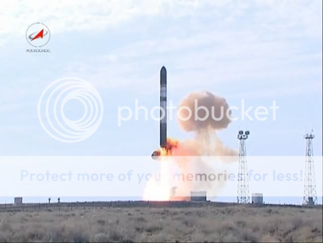
Launch site: Baikonur Cosmodrome, Kazakhstan

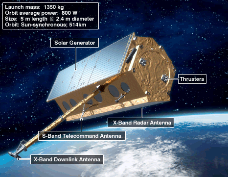
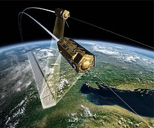
An ISC Kosmotras Dnepr rocket will launch the TanDEM-X satellite for the German Aerospace Center (DLR) and Astrium. TanDEM-X stands for TerraSAR-X add-on for Digital Elevation Measurement. The satellite will fly in close formation with the TerraSAR-X spacecraft launched in 2007 to gather precise elevation data.

TanDEM-X

orb has posted a great package to Orbiter Forum: http://www.orbiter-forum.com/showthread.php?t=16461 (plenty of nice photos)
TerraSAR-X Wikipedia Article: http://en.wikipedia.org/wiki/TerraSAR-X#The_future
EADS Astrium TanDEM-X Brochure: http://www.astrium.eads.net/media/docum ... m-x_en.pdf

tandem-x-terrasar-x-formation-eo-earth-lg.jpg


TanDEM-X Arrives to Baikonur:
[youtube]http://www.youtube.com/watch?v=Ck57eqU9qko[/youtube]

Live Streaming

German Aerospace Center: http://www.livestream.com/dlrgermanaerospacecenter
TanDEM-X Launchcast: http://infoterra.de/tandem-x-launchcast.html
DLR Portal - Early Bird Special: http://www.dlr.de/en/desktopdefault.asp ... ead-25089/
TV Tsenki Live1: http://www.tv-tsenki.com/live.php
TV Tsenki Live3: http://www.tv-tsenki.com/live3.php (usually better than Live1)

Dnepr Launch Vehicle

ISC Kosmotras Dnepr Launch Vehicle Page: http://www.kosmotras.ru/en/rn_dnepr/
ISC Kosmotras Dnepr Program Page: http://www.kosmotras.ru/en/program_dnepr/
Astronautix Dnepr Infos: http://www.astronautix.com/lvs/r36m.htm#Dnepr
Dnepr Wikipedia Article: http://en.wikipedia.org/wiki/Dnepr_rocket
NPO InterCoS Dnepr LV Page: http://www.npointercos.jp/DneprLV.html

mission_profile_eng.jpg


Dneprmissionprofiless.jpg


ph_dnepr_1_en.gif


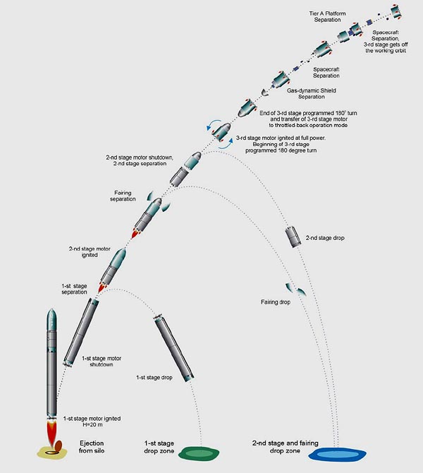
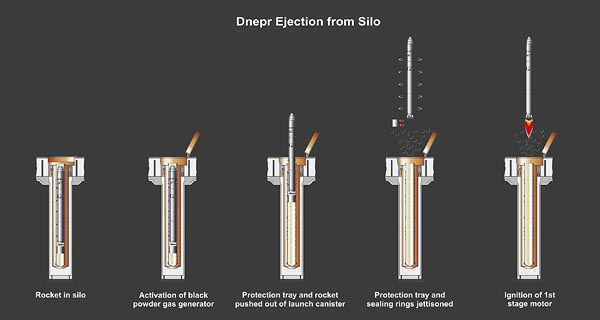
Ejection from silo/canister

GAS generator ejects Dnepr out from its silo or canister.

LaunchfromSilo.jpg


070105_genesis_hLarge.hlarge.jpg


First Stage

One RD-264 engine burning N[sub]2[/sub]O[sub]4[/sub]/UDMH

Astronautix RD-264 Page: http://www.astronautix.com/engines/rd264.htm

h_aff2e6cb9e865be678362e36efeab836


Second Stage

One RD-0255 engine burning N[sub]2[/sub]O[sub]4[/sub]/UDMH

Astronautix RD-0255 Page: http://www.astronautix.com/engines/rd0255.htm
RD-0255 Manufacturer KBKhA: http://www.kbkha.ru/?lang=en

Third Stage

One RD-869 engine burning N[sub]2[/sub]O[sub]4[/sub]/UDMH

Astronautix RD-869 Page: http://www.astronautix.com/engines/rd869.htm
RD-869 Designer Yuzhnoye: http://www.yuzhnoye.com/?lang=en

Baikonur Kosmodrome

Baikonur Kosmodrome Wikipedia Article: http://en.wikipedia.org/wiki/Baikonur_Cosmodrome
Russianspaceweb Baikonur Page: http://www.russianspaceweb.com/baikonur.html
Russianspaceweb Baikonur Downrange Page: http://www.russianspaceweb.com/baikonur_downrange.html
Russianspaceweb Baikonur Facilities Page: http://www.russianspaceweb.com/baikonur_facilities.html
Historical Photos from Baikonur Kosmodrome: http://www.buran.ru/htm/baykonur.htm
NASA's Baikonur Page: http://www.nasa.gov/mission_pages/stati ... konur.html
Google Maps Link: http://maps.google.com/maps?t=h&q=45.96 ... 30341&z=15
Baikonur-info.ru: http://translate.google.com/translate?j ... l=ru&tl=en
(without Google Translation: http://www.baikonur-info.ru/)

149273main_fgb_illu_bmap.gif
 
E

EarthlingX

Guest
Re: June 20, Dnepr - TanDEM-X

I checked around the YouTube a bit, found a couple of nice older videos, and this one seems most related :

[youtube]http://www.youtube.com/watch?v=vzpk3tMDCtg[/youtube]
 
E

EarthlingX

Guest
Re: June 20, Dnepr - TanDEM-X

Everything seems to be ok, they are headed to the bar to celebrate ..
 
Z

Zipi

Guest
Spaceflight Now has a small announcement:
20dnepr_400252.jpg

Radar mapping spacecraft launched into Earth orbit

Germany's TanDEM-X satellite has been successfully launched into orbit where it will fly alongside another radar spacecraft and compile precise elevation data about the planet. The Dnepr launch vehicle took flight at 0214 GMT (10:14 p.m. EDT) when the converted missile popped out of its silo at the Baikonur Cosmodrome in Kazkahstan.
 
E

EarthlingX

Guest
http://www.dlr.de : The Earth in 3D - German radar satellite TanDEM-X launched successfully
21 June 2010


Flying in formation, TanDEM-X and TerraSAR-X

Germany's second Earth observation satellite, TanDEM-X, was launched successfully on 21 June 2010 at 04:14 Central European Summer Time (CEST, at 08:14 local time) from the Baikonur Cosmodrome in Kazakhstan. Atop a Russian Dnepr rocket, the satellite, weighing more than 1.3 tons and five metres in length, started its journey into orbit. At 4.45 CEST first signal was received via Troll ground station in the Antarctic.

TanDEM-X is being run as a public-private partnership (PPP) between the DLR Astrium GmbH, with DLR funding coming from the German Ministry of Economics and Technology. Infoterra GmbH, a subsidiary of Astrium, is responsible for the commercial marketing of the TanDEM-X data. Astrium GmbH in Friedrichshafen built the satellite and is sharing the costs for its development and operation. The TanDEM-X mission has a total cost of 165 million Euros. DLR is contributing 125 million Euros and the European space company Astrium is contributing 40 million Euros.

Together with its twin satellite TerraSAR-X, in space since 2007, TanDEM-X will survey the entire land surface area of the Earth - a total of 150 million square kilometres - several times over. It will accomplish this from an altitude of 514 kilometres within three years. "This will be the first time we will ever have had a globally standardised 3D digital elevation model of Earth, and with a measuring point density of 12 metres, it will be incredibly accurate," said Prof. Dr Alberto Moreira, Science Director of the TanDEM-X mission and Director of the DLR Microwaves and Radar Institute.


TerraSAR-X and TanDEM-X flying in close formation

Today, for large areas of Earth, there are only approximate, non-standardised or incomplete elevation models, and it is these gaps that the TanDEM-X mission is designed to fill. To accomplish this, TanDEM-X and TerraSAR-X will fly just a few hundred metres apart and will constitute the first configurable synthetic aperture radar (SAR) interferometer in space.

Digital elevation models can be used in a huge range of applications. Geoscientific disciplines such as hydrology, geology and oceanography require precise and up-to-date information on the properties of the Earth's surface. Digital elevation models can help to make the exploitation of natural resources more efficient and can also help to optimise relief planning in the wake of natural disasters, as well as security deployments. Digital maps are also essential to reliable navigation: their precision needs to keep pace with the increasingly stringent requirements that govern global positioning.


TanDEM-X elevation model

A network of three TanDEM-X grounds stations (Kiruna in Sweden, Inuvik in Canada and O'Higgins in the Antarctic) is ready and waiting for the immense volume of raw data that the satellites will generate. This data will be processed in three main steps: initially, the data transmitted by TanDEM-X to these ground stations will be examined. Then the results will be evaluated at the DLR’s German Remote Exploration Data Center (DFD) in Oberpfaffenhofen and processed into raw versions of elevation models. The global digital elevation model is then generated by a unit known as the mosaicking and calibration processor. The data records for the global elevation model will amount to 15 terabytes and will be available about four years after the launch of TanDEM-X.


Network of ground stations


www.federalspace.ru : Converted Russian ICBM Takes German Satellite into Orbit
:: 21.06.2010

A converted Russian intercontinental ballistic missile took Germany's TanDEM-X satellite into orbit on Monday, a military spokesman said.
The RS-20B carrier rocket lifted off from the Baikonur space center in Kazakhstan at 6:14 Moscow time [2:14 GMT].
This is the 16th launch of an international satellite under the Dnepr program involving Russia, Ukraine, Kazakhstan and Turkmenistan, which converts RS-20 ICBMs (classified by NATO as the SS-18 Satan) into carrier rockets to put satellites into low Earth orbit. Around 50 satellites have been put into orbit so far.
"The RS-20B rocket took the TanDEM-X satellite into orbit," Col. Vadim Koval said.
The 1,350-kg TanDEM-X satellite, with a life span of five years will survey Earth's land surface several times during its mission. The primary objective of the mission is to generate a consistent global digital elevation model of an unprecedented accuracy.
Russian-Ukrainian joint venture Kosmotras uses launch pads at the Baikonur space center in Kazakhstan and Russia's Strategic Missile Forces facilities equipped for RS-20 launches.
The RS-20 is the most powerful ICBM in the world. It was first launched in 1973 and is still in service with Russia's Strategic Missile Forces.

RIA Novosti
 
E

EarthlingX

Guest
http://www.dlr.de : TanDEM-X sends its first images in record time
25 June 2010
Last update: 25/06/2010 17:10:51

Radar satellite views of Madagascar, Ukraine and Moscow

Already, with its first image acquisitions, TanDEM-X (TerraSAR-X add-on for Digital Elevation Measurement) has surpassed its twin satellite, TerraSAR-X. On 24 June 2010, only 3 days and 14 hours into the mission, the satellite sent its first image data back to Earth. The transmission was received by the German Aerospace Center (Deutsches Zentrum fŸr Luft- und Raumfahrt; DLR) ground station at Neustrelitz and processed to produce images. TanDEM-X looked down from an altitude of more than 500 kilometres above northern Madagascar, Ukraine and Moscow.


Madagascar seen from space


Moscow from 500 kilometres high

With the end of the launch and early orbit phase this weekend, the TanDEM-X team begins the first part of the commissioning phase, during which the satellite is ‘put through its paces’. “It takes about three months to prepare it for operational use,” says Bartusch. By the end of July, the two satellites will be brought within 20 kilometres of one another. In October, is will be another, unique milestone: the satellites will fly in formation with a distance of only some 200 metres separating them as they orbit the Earth. This marks the second part of the commissioning phase, during which the approach and control of both satellites is in focus.
 
Z

Zipi

Guest
Some nice shots how Dnepr's launch silo is refurbished:
[youtube]http://www.youtube.com/watch?v=gTI91mAPFxk[/youtube]
 
E

EarthlingX

Guest
http://www.spacemart.com : The Face Of The Earth
by Thomas Fritz
Bonn, Germany (SPX) Aug 30, 2010

For a month now, we have been acquiring altitude models with the TanDEM-X and TerraSAR-X satellite pair. Already, over 1000 products have come out of our operational processing chain. Alongside many test images, some of the data also give an insight into how humankind has shaped the surface of the Earth - and how the highs and lows around them have determined the course of their lives.


Mount Teide, Tenerife. 3D view of a TanDEM-X digital elevation model combined with radar intensity data. Credit: DLR. To see the other images mentioned in the body of this article please go here.
 
E

EarthlingX

Guest
http://www.dlr.de : A connection with antennas - TanDEM-X project leader Manfred Zink
11 October 2010

By Bernadette Jung


Manfred Zink, Project Manager for the TanDEM-X ground segment

Manfred Zink likes to organise things. For the TanDEM-X radar satellite mission he is organising when and where the antennas of the satellites are to point, in order to acquire the best three-dimensional images possible of our planet. Manfred Zink is Project Manager for the Ground Segment of the mission at the German Aerospace Center (Deutches Zentrum für Luft- und Raumfahrt; DLR) in Oberpfaffenhofen. He is responsible for directing the entire mission, from the close flight formation of the TerraSAR-X and TanDEM-X satellites to the creation of the digital elevation model. This is the thirteenth of our series of portraits on the DLR web portal.

One look at his desk is enough to see where the 47-year-old physicist's heart is. To the left side, close to the window, are photos of his family, at the other end are miniature models of the TerraSAR-X and TanDEM-X satellites. The actual satellites have been orbiting Earth together since June 2010, and from October 2010 they will be flying with each other in a close helical path to scan Earth’s surface from different viewing angles using their radars.
Close formation flight, the critical phase of the mission, is just around the corner. In early October, the distance between the satellites will be reduced from 20 kilometres to just 200 metres, at an orbital speed of 27,000 kilometres an hour.

TerraSAR-X and TanDEM-X in formation flight
"I've got butterflies in my stomach. No one has ever flown two satellites so close to each other before. The control system is very complicated and we have to be precise to the last decimal point. After all, neither of the two satellites knows that the other is there, so to speak. It's especially difficult to match the two radar systems to one another and keep them synchronised," he explains. During a radar imaging series, the two satellites exchange synchronisation signals ten times a second, and everything has to be set up correctly in advance. This is the only way can we obtain precise and state-of-the-art elevation models of Earth's surface.
...

TanDEM-X digital elevation model: the Aracar volcano on the Chilean-Argentinian border
...
 
E

EarthlingX

Guest
www.dlr.de : Initial reports of success from the control room
13. October 2010, 17.01,

Harald Hofmann

kontroll_raum_200x150.jpg


We are off again; the team at the German Space Operation Center (GSOC) and their colleagues from EADS Astrium gathered two days ago in the control room to manage the transition to close formation flight. We began the first manoeuvre on Monday, 11 October 2010; this is referred to as the ‘drift start’ manoeuvre, which gives the TanDEM X satellite (TDX) the necessary momentum to close to a distance of one kilometre behind TerraSAR X (TSX) within a few days.

Beginning on Wednesday morning, we have resumed working in shifts and are monitoring the status of the two satellites with more than 15 contacts per day per satellite – that is, we have at least one contact per orbit with each satellite, in order to be able to intervene (almost) immediately in the event of trouble. We were able to enjoy our first success before the beginning of this morning’s shift at 09:00 local time – the ‘inter-satellite link’, which sends status data from TSX to TDX and makes it possible for TDX to react to problems, had already transferred its first data earlier in the day.

Meanwhile, the satellites have already closed to a separation of two kilometres, and we look forward to implementing the ‘drift stop’ manoeuvre with which we complete the approach phase. From this point, only a few small manoeuvres will be necessary to arrive precisely in the required formation.

Until then – that is, until Friday morning – we will be carefully monitoring every contact with the satellites from the control room. Once we can confirm that close formation flight has been achieved, we hope to return to normal working hours. But we will, of course, continue to keep a careful eye on TSX and TDX as the radar satellites continue their ‘dance’ together.
 
E

EarthlingX

Guest
http://www.dlr.de : TerraSAR-X and TanDEM-X flying in close formation
15 October 2010

The German Aerospace Center (Deutsches Zentrum für Luft- und Raumfahrt; DLR) and the space company Astrium have recently taken an important step forward in their mission to create a three-dimensional map of the world. On 14 October 2010, the radar satellite TanDEM-X moved into close formation with its 'twin', TerraSAR-X. Before this, the two satellites were orbiting 20 kilometres apart - a flight time of almost three seconds. Now, there are only 350 metres separating the pair, which means their antennas are able to acquire radar images of the same area simultaneously. The objective of the mission is to create a high-precision, three-dimensional digital elevation model of Earth's land surface. The project needs the satellites to operate in parallel for a period of three years. The transition to close formation flight marks the beginning of the final preparatory stage of the TanDEM-X mission. The routine operations phase is due to start in early January next year.
...
The TerraSAR-X and TanDEM-X orbit trajectories, patented by DLR researchers, are like the strands of a double helix - they circle around one another without crossing. The team of scientists based in DLR Oberpfaffenhofen took just three days to carry out the approach in preparation for the final formation flight. "First, we had to manoeuvre TanDEM-X to reduce its orbital period, so that the satellite could 'catch up', reducing the 20 kilometre gap between it and TerraSAR-X. After two further manoeuvres we brought the distance between the pair down to 350 metres," explains DLR flight dynamics expert Ralph Kahle.

The reduced distance between the satellites means that the two radar systems can be synchronised for the first time. TerraSAR-X and TanDEM-X can also monitor each other's 'health' via an inter-satellite link. "This is completely uncharted territory. Never before have two satellites worked in such close formation over a period of several years," says Manfred Zink, Project Manager for the TanDEM-X Ground Segment. Eckard Settelmeyer, Director of Earth Observation and Science at Astrium, adds: "This dual mission will give another boost to satellite-supported applications and science."
...
The close formation flight marks the bistatic phase of the TanDEM-X mission. The two radar satellites no longer work independently, but in synchronisation. One satellite transmits the radar signals needed for image acquisition, but then both satellites receive the signals reflected from the ground. "Only in this bistatic mode can we get the image quality we need for the global elevation model. It marks an important milestone in the mission," says Zink. Working in close formation, TerraSAR-X and TanDEM-X's antennas complement one another like a pair of eyes. The combination of both radar images will no longer suffer from temporal changes between subsequent acquisitions over water or forest areas, and the combined sets of data can be processed into high-quality elevation models.

There are also energy-related benefits to this recording method. Because of the power consumption and build-up of heat, a radar satellite has a limit to the length of time for which it can transmit. However, in bistatic mode, TerraSAR-X and TanDEM-X share the transmission task. This means that the DLR scientists can use double the acquisition time that is available with one satellite
...
The comprehensive testing program for the TanDEM-X mission is expected to run until the end of 2010; then, the acquisition of data for the global elevation model can begin. In the current phase, DLR researchers will ensure that the close formation flight is optimised, the bistatic recordings are being captured correctly and the image processors are working as specified. With the successful transition to close formation flight, DLR is close to the operational phase of the TanDEM-X satellite mission.
...


http://www.bbc.co.uk : German radar satellites fly tight space waltz
15 October 2010 Last updated at 07:47 GMT

By Jonathan Amos

It is a remarkable acrobatic display.

Two German radar satellites are now flying in tight formation as they prepare to make the most detailed ever 3D map of the Earth's entire surface.

TanDEM-X and TerraSAR-X have moved to within 350m of each other as they sweep around the planet at 7km/s.

The pair will soon begin an intense observation campaign that will pin down the variation in height across the globe to an accuracy of better than two metres.
...
The very close proximity manoeuvres were conducted step-by-step over the course of the past week.

"It's tricky and I must confess we've all been a bit nervous," Manfred Zink, from the German space agency (DLR), told BBC News.
...
This operational flight profile is thought to be unique in civil space history.

Although vehicles approaching the space station, such as the shuttle, will frequently hold their position just metres away from the platform, this formation flying is very short-lived.

TanDEM-X and TerraSAR-X, in contrast, will spend the next three years turning about each other; and the current separation distance is not even the shortest planned. That will be just 200m.

"The closest will be adjusted when we are through the commissioning phase," explained Dr Zink, who is project manager for the TanDEM-X ground segment. "We hope that by Christmas we can finish all the various tests that are still outstanding, and to start the acquisition of the global DEM data."
...
 
E

EarthlingX

Guest
http://www.dlr.de : TanDEM-X and TerraSAR-X – imaging Etna while flying in formation
19 October 2010

First synchronised elevation model for radar satellite pair

The TanDEM-X and TerraSAR-X satellite pair have acquired their first image of Earth’s surface, synchronised to the microsecond, while flying over Mount Etna in Italy. Scientists at the German Aerospace Center (Deutsches Zentrum für Luft- und Raumfahrt; DLR) have used the data to create a three-dimensional digital elevation model with an unprecedented elevation accuracy down to two metres. The image, taken while the satellites were flying just 350 metres apart, is the first in the world to be made by satellites flying in such a close formation.
...

Mount Etna in three dimensions
...
Comparison of the TanDEM-X elevation model with data acquired ten years previously by SRTM demonstrates the improvement in precision; the difference between the elevations measured today and the SRTM elevation data is represented in colour on a TanDEM-X radar image of the area surrounding Mount Etna. In the area of the actual crater especially and along the flanks of the volcano there are differences of up to 30 metres.

Data from TanDEM-X and SRTM compared
...

Eyjafjallajökull volcano in Iceland
...

A snapshot of land and water – Franz Josef Land in the Arctic Ocean
...
 
Status
Not open for further replies.