M
MESSENGER Mercury Updates.
Page 26 - Seeking answers about space? Join the Space community: the premier source of space exploration, innovation, and astronomy news, chronicling (and celebrating) humanity's ongoing expansion across the final frontier.
You are using an out of date browser. It may not display this or other websites correctly.
You should upgrade or use an alternative browser.
You should upgrade or use an alternative browser.
- Status
- Not open for further replies.
M
MeteorWayne
Guest
Wow!! Some super new images:
http://messenger.jhuapl.edu/gallery/sciencePhotos/
Date Acquired: September 29, 2009
Image Mission Elapsed Time (MET): 162744150
Instrument: Narrow Angle Camera (NAC) of the Mercury Dual Imaging System (MDIS)
Resolution: 0.40 kilometers/pixel (0.25 miles/pixel)
Scale: The basin is approximately 260 kilometers (160 miles) in diameter
Spacecraft Altitude: 15,600 kilometers (9750 miles)
Of Interest: This unnamed impact basin was seen for the first time yesterday during MESSENGER’s third flyby of Mercury. The outer diameter of the basin is approximately 260 kilometers (160 miles). This basin has a double-ring structure common to basins with diameters larger than 200 kilometers (about 125 miles). The floor of the basin consists of smooth plains material. Concentric troughs, formed by surface extension, are visible on the basin floor, similar to those seen in Raditladi basin. Such troughs are rare on Mercury, and the discovery of such features in this newly imaged basin is of great interest to members of the MESSENGER Science Team. Crater chains produced during ejecta emplacement also can be seen emanating from the basin.
Credit: NASA/Johns Hopkins University Applied Physics Laboratory/Carnegie Institution of Washington

H
halcyondays
Guest
M
MeteorWayne
Guest
unforunately Andrew is not available right now. He hopes to be back soon.
Some bad news about the flyby:
http://www.space.com/scienceastronomy/0 ... iccup.html
A NASA spacecraft that completed its third and final flyby of the planet Mercury yesterday, snapping new pictures of the innermost planet, had a small data hiccup that has delayed release of the images, mission engineers said today.
The MESSENGER probe skimmed just 142 miles (228 km) above Mercury at its closest approach as it whipped around the planet during the flyby, the last of three designed to guide the spacecraft into orbit around the planet in 2011.
The spacecraft did snap several new images of the rocky planet on the inbound leg of its close approach.
"We do have some new science from the flyby," said MESSENGER project scientist Ralph McNutt of Johns Hopkins University Applied Physics Laboratory.
MESSENGER also took snapshots during its close approach, but "we had a little bit of a hiccup in the data" that has delayed the release of those images, said Eric Finnegan, systems engineer for the mission at Johns Hopkins APL. "It's coming," he added.
The anomaly appears to have happened right around the spacecraft's close approach, so there may not be images from the outbound leg of the journey, McNutt said.
M
MeteorWayne
Guest
spaceflightnow is reporting all outbound observations were lost due to a power problem during eclipse. They hope to have science obs up again by Saturday.
Still, remember, the primary purpose of the flyby was to adjust the path for orbital insertion in 2011, and it appears that was 100% sucessful.
Looking for more data on the NASA site...
http://messenger.jhuapl.edu/news_room/d ... php?id=136
Still, remember, the primary purpose of the flyby was to adjust the path for orbital insertion in 2011, and it appears that was 100% sucessful.
Looking for more data on the NASA site...
http://messenger.jhuapl.edu/news_room/d ... php?id=136
B
BCstargazer
Guest
great posts...what about that bright spot?? i think i read on S&T that it had been discovered from telescopic observations from eath !! wow...you can see the irregular depression that seems to be somehow connected to the material...any info would be greatly appreciated.
the pic at the mission site is:
http://messenger.jhuapl.edu/gallery/sci ... age_id=336
the pic at the mission site is:
http://messenger.jhuapl.edu/gallery/sci ... age_id=336
D
docm
Guest
Nice full shot of Mercury as MESSENGER heads out...
Large version: 21 meg PNG (8400x8400) Best to right-click/Save As

My crop of the bright crater @ image center (actual pixels).....

My crop of the bright crater @ image 5 o'clock (actual pixels).....

Large version: 21 meg PNG (8400x8400) Best to right-click/Save As

My crop of the bright crater @ image center (actual pixels).....

My crop of the bright crater @ image 5 o'clock (actual pixels).....

D
docm
Guest
M
MeteorWayne
Guest
WASHINGTON -- NASA will host a media teleconference at 1 p.m. EST on Tuesday, Nov. 3, to announce scientific findings and release new images from the third and final flyby of Mercury by the Mercury Surface, Space Environment, Geochemistry and Ranging spacecraft, known as MESSENGER.
The probe's cameras and instruments collected high-resolution and color images of the planet on Sept. 29, unveiling another six percent of Mercury's surface never before seen by a spacecraft.
The briefing participants are:
- Sean Solomon, principal investigator, Carnegie Institution of Washington
- Ronald J. Vervack, Jr., participating scientist, The Johns Hopkins University Applied Physics Laboratory (APL) in Laurel, Md.
- David J. Lawrence, participating scientist, APL
- Brett Denevi, imaging team member and postdoctoral researcher, Arizona State University, Tempe
3
3488
Guest
Thank you very much far all of the updates Wayne. Also thank you too to docm for those remarkable images.
It looks like MESSENGER had tripped due to the drop in temperature close to Periherm hense the safing. However MESSENGER had already completed two similar encounters before, so I wonder why third time round it was a problem???
I will get up to speed with images etc in due course.
Andrew Brown.
It looks like MESSENGER had tripped due to the drop in temperature close to Periherm hense the safing. However MESSENGER had already completed two similar encounters before, so I wonder why third time round it was a problem???
I will get up to speed with images etc in due course.
Andrew Brown.
3
3488
Guest
Mercury inbound crescent in true & false colour.
Evidence of explosive volcanism on Mercury?
The irrugalr shaped depression a suspected caldera is 30 KM across.

I hope to be back with decent crops etc soon, when I'm back up to strength.
Countdown to Orbital Insertion around Mercury.
480 Days.
19 Hours.
20 Minutes.
15 Seconds.
Andrew Brown.
Evidence of explosive volcanism on Mercury?
The irrugalr shaped depression a suspected caldera is 30 KM across.

I hope to be back with decent crops etc soon, when I'm back up to strength.
Countdown to Orbital Insertion around Mercury.
480 Days.
19 Hours.
20 Minutes.
15 Seconds.
Andrew Brown.
3
3488
Guest
A long scarp revisited.
Countdown to Orbital Insertion around Mercury.
478 Days.
19 Hours.
48 Minutes.
45 Seconds.
Andrew Brown.
Countdown to Orbital Insertion around Mercury.
478 Days.
19 Hours.
48 Minutes.
45 Seconds.
Andrew Brown.
3
3488
Guest
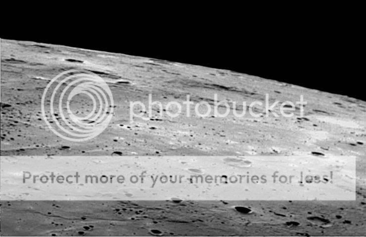
A view over Mercury's southern horizon.

Countdown to Orbital Insertion around Mercury.
468 Days.
16 Hours.
1 Minute.
15 Seconds.
Andrew Brown.

Countdown to Orbital Insertion around Mercury.
468 Days.
16 Hours.
1 Minute.
15 Seconds.
Andrew Brown.
3
3488
Guest
This week's update.
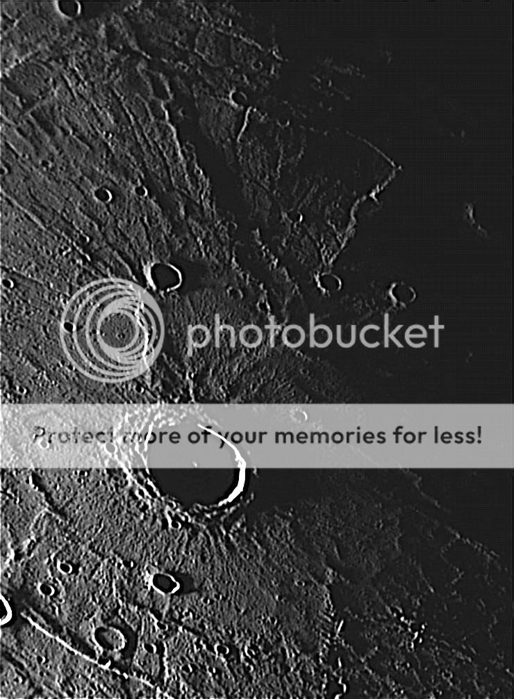
Rembrandt Basin at Hermean Sunset.

Countdown to Orbital Insertion around Mercury.
460 Days.
17 Hours.
5 Minutes.
15 Seconds.
Andrew Brown.
Rembrandt Basin at Hermean Sunset.

Countdown to Orbital Insertion around Mercury.
460 Days.
17 Hours.
5 Minutes.
15 Seconds.
Andrew Brown.
3
3488
Guest
I've cropped out enlarged & sharpened the central portion of the Rembrandt Basin at Sunset image.
Countdown to Orbital Insertion around Mercury.
459 Days.
19 Hours.
38 Minutes.
00 Seconds.
Andrew Brown.

Countdown to Orbital Insertion around Mercury.
459 Days.
19 Hours.
38 Minutes.
00 Seconds.
Andrew Brown.
Z
Zipi
Guest
3
3488
Guest
Zipi":348tb3wn said:
Thank you very much Zipi.
That is quite a tool on that site. I have a lot of fun looking around on it, very clearly showing the distribution of the basins, larger imnpact craters, lava plains, rupes, suspected volcanic craters, etc. :mrgreen:
Nearly the first full global map of Mercury, courtesy of Mariner 10 (back in 1974) & MESSENGER. Only a small'ish' area around both poles remain unimaged.
Planetary Photojournal entry.
JHU MESSENGER Site Article
It is quite a map, quite a fantastic piece of work.
When MESSENGER reaches Hermcentric orbit, then the coverage will be complete with consistant illumination. This map was put together using three MESSENGER passes with the sun shining from opposite directions for the first two & Mariner 10, the sun was shining more or less at another 90 degree angle with respect to MESSENGER.
This map is still a stunning achievement though. :shock:
Countdown to Orbital Insertion around Mercury.
456 Days.
19 Hours.
4 Minutes.
00 Seconds.
Andrew.
3
3488
Guest
This week's update. Mercury MESSENGER Highlights of 2009.
Mercury MESSENGER highlights for 2009.
Countdown to Orbital Insertion around Mercury.
449 Days.
3 Hours.
54 Minutes.
45 Seconds.
Andrew Brown.
Mercury MESSENGER highlights for 2009.
Countdown to Orbital Insertion around Mercury.
449 Days.
3 Hours.
54 Minutes.
45 Seconds.
Andrew Brown.
3
3488
Guest
First update of 2010.
Lava Plains, ghost craters & embayed craters on Mercury.
Observations like these by MESSENGER are revealing the extent of volcanic activity in Mercury's past.

Countdown to Orbital Insertion around Mercury.
429 Days.
18 Hours.
57 Minutes.
45 Seconds.
Andrew Brown.
Lava Plains, ghost craters & embayed craters on Mercury.
Observations like these by MESSENGER are revealing the extent of volcanic activity in Mercury's past.

Countdown to Orbital Insertion around Mercury.
429 Days.
18 Hours.
57 Minutes.
45 Seconds.
Andrew Brown.
3
3488
Guest
This weeks update from the MESSENGER mission got me thinking (if indeed I am capable of thinking)!!!!!
Back in 1974 Mariner 10 first saw Mercury in high resolution & it was apparent that Mercury was largely covered in lava plains, dotted with mostly small craters (Mercury sports giant craters & basins too of course).
Mariner 10 could only image 45% of Mercury despite three close approaches as the spacecraft was in resonance with Mercury, Mercury orbited the Sun twice for every one of Marnier 10's orbits. Mercury rotates three times for every two orbits around the sun, so every orbit Mercury makes, alternate hemispheres face the Sun. Mariner 10 therefore only saw the same side three times (though the second pass took Mariner 10 over the south polar region, the first & third passes were equatorial night side close approaches).
So for over 30 years, 55% of Mercury was largely unknown. Questions arose, such as, did Marner 10 show us a fair representation of Mercury, or is the remaining 55% hiding strange & unusual features, etc???
MESSENGER has now bought the coverage up to approx 98% of the total surface (there are some areas that only Mariner 10 has seen to date, particularly to the east of the Caloris Basin & the south pole).
MESSENGER has shown us that what Mariner 10 did see is fairly representative of Mercury as a whole. However, MESSENGER has shown some features that Mariner 10 missed including a 75 KM wide Shield Volcano with a 25 KM wide Heart Shaped caldera, the interior of Caloris Basin, discovered another large basin in the southern hemisphere, since named Rembrandt, several large double ringed craters, more rinkle ridges & Rupes (giant scarps when Mercury contracted slightly as the core began to cool & are likely still growing very slowly) & other features indicative of volcanic activity.
What will be even more interesting will be when MESSENGER finally inserts into orbit around Mercury on Friday 11th March 2011 & begins the primary orbital mission.
The lava plains in places look as though they overlap. So far Mariner 10 & MESSENGER imagery are of fairly similar resolution, the best images from both being around 70 - 100 metres from only a very few locations. MESSENGER when at it's low point will reveal details as small as 18 metres, perhaps that low point being lowered in a possible extended mission, revealing even finer detail. However these images will not be confined to a few small regions, rather a swathe over the mid northern latitudes including Caloris Basin & the peculiar shield volcano.
However many of the overlapping lava plains will also be seen at this detail & it will be interesting to see if lets say, the top most layers have fewer tiny craters then the lower exposed lava plains, so to speak, to build up a crater count that can help date each successive layer? The high resolution images of the shield volcano will really interest me particularly (I have attached some here from MESSENGER's first pass, future images will be very much sharper).
Shield Volcano on Mercury seen on first MESSENGER pass.
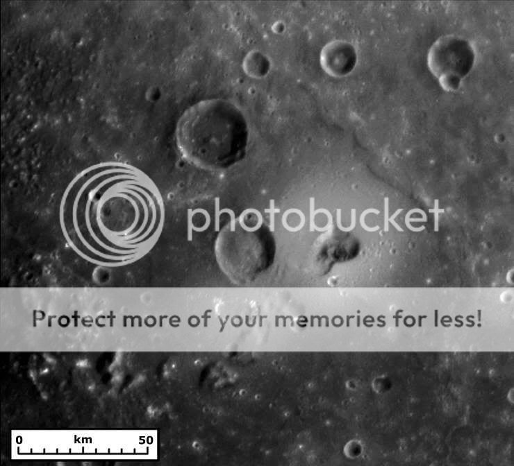
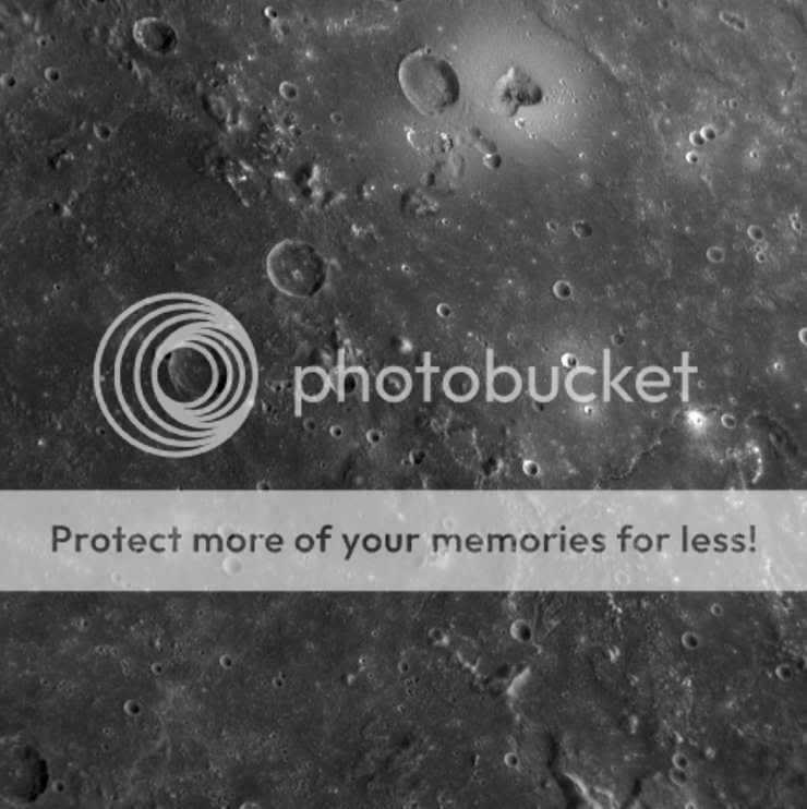
25 KM wide summit caldera of shield volcano.

Equatorial lava plains seen during the second MESSENGER pass.
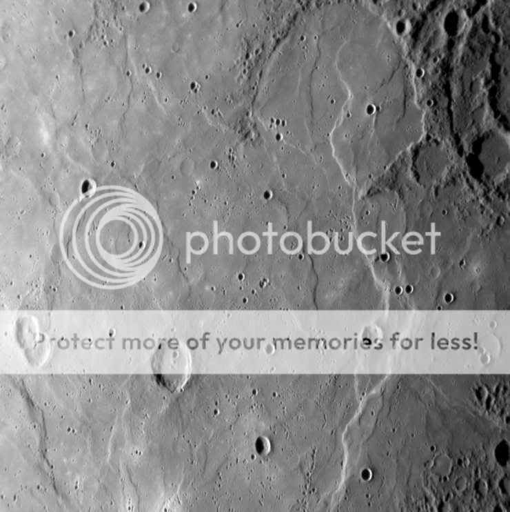
400 KM wide area of equatorial lava plains, lava flooded ghost craters & embayed craters, seen during the third MESSENGER pass of Mercury.
Countdown to Orbital Insertion around Mercury.
426 Days.
18 Hours.
22 Minutes.
15 Seconds.
Andrew Brown.
Back in 1974 Mariner 10 first saw Mercury in high resolution & it was apparent that Mercury was largely covered in lava plains, dotted with mostly small craters (Mercury sports giant craters & basins too of course).
Mariner 10 could only image 45% of Mercury despite three close approaches as the spacecraft was in resonance with Mercury, Mercury orbited the Sun twice for every one of Marnier 10's orbits. Mercury rotates three times for every two orbits around the sun, so every orbit Mercury makes, alternate hemispheres face the Sun. Mariner 10 therefore only saw the same side three times (though the second pass took Mariner 10 over the south polar region, the first & third passes were equatorial night side close approaches).
So for over 30 years, 55% of Mercury was largely unknown. Questions arose, such as, did Marner 10 show us a fair representation of Mercury, or is the remaining 55% hiding strange & unusual features, etc???
MESSENGER has now bought the coverage up to approx 98% of the total surface (there are some areas that only Mariner 10 has seen to date, particularly to the east of the Caloris Basin & the south pole).
MESSENGER has shown us that what Mariner 10 did see is fairly representative of Mercury as a whole. However, MESSENGER has shown some features that Mariner 10 missed including a 75 KM wide Shield Volcano with a 25 KM wide Heart Shaped caldera, the interior of Caloris Basin, discovered another large basin in the southern hemisphere, since named Rembrandt, several large double ringed craters, more rinkle ridges & Rupes (giant scarps when Mercury contracted slightly as the core began to cool & are likely still growing very slowly) & other features indicative of volcanic activity.
What will be even more interesting will be when MESSENGER finally inserts into orbit around Mercury on Friday 11th March 2011 & begins the primary orbital mission.
The lava plains in places look as though they overlap. So far Mariner 10 & MESSENGER imagery are of fairly similar resolution, the best images from both being around 70 - 100 metres from only a very few locations. MESSENGER when at it's low point will reveal details as small as 18 metres, perhaps that low point being lowered in a possible extended mission, revealing even finer detail. However these images will not be confined to a few small regions, rather a swathe over the mid northern latitudes including Caloris Basin & the peculiar shield volcano.
However many of the overlapping lava plains will also be seen at this detail & it will be interesting to see if lets say, the top most layers have fewer tiny craters then the lower exposed lava plains, so to speak, to build up a crater count that can help date each successive layer? The high resolution images of the shield volcano will really interest me particularly (I have attached some here from MESSENGER's first pass, future images will be very much sharper).
Shield Volcano on Mercury seen on first MESSENGER pass.


25 KM wide summit caldera of shield volcano.

Equatorial lava plains seen during the second MESSENGER pass.

400 KM wide area of equatorial lava plains, lava flooded ghost craters & embayed craters, seen during the third MESSENGER pass of Mercury.

Countdown to Orbital Insertion around Mercury.
426 Days.
18 Hours.
22 Minutes.
15 Seconds.
Andrew Brown.
3
3488
Guest
This weeks update, more of a recap from the first encounter in January 2008.
Lange Crater & Benoit Crater.

Countdown to Orbital Insertion around Mercury.
422 Days.
22 Hours.
2 Minutes.
00 Seconds.
Andrew Brown.
Lange Crater & Benoit Crater.

Countdown to Orbital Insertion around Mercury.
422 Days.
22 Hours.
2 Minutes.
00 Seconds.
Andrew Brown.
3
3488
Guest
Thw latest update, the first for at least a couple of weeks.
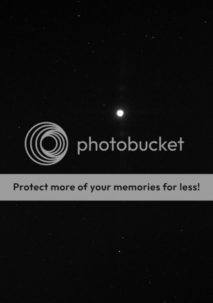
MESSENGER on: Saturday 16th January 2010 obtained 256 images of the region of the sky close to the Sun (with the Sun literally just out of the frame) in the latest search for Vulcanoids.
Below is one image taken by MESSENGER's WAC (Wide Angle Camera) on the MDIS (Mercury Dual Imaging System), showing the planet Venus, which was then 144 Million KM from MESSENGER & is vastly overexposed. The three brightest stars below Venus are Sigma Sagittarii / Nunki, Tau Sagittarrii & Zeta Sagittarii / Ascella, the three easternmost stars of the Teapot asterism of Sagittarius the Archer.
So far MESSENGER has not spotted any Vulcanoids, a postulated 'belt' of asteroids orbiting the Sun at a distance of approx 27 million KM or approx half of Mercury's average distance from the Sun.
Myself, I do not think they exist, but having a spacecraft capable of detecting small ones of only a few KM across, if they exist, in an ideal position, it is silly to not utilise the opportunity to look.
MESSENGER was close to Perihelion at the time with the solar intensity being approx 11 times greater than from Earth.
Countdown to Orbital Insertion around Mercury.
408 Days.
22 Hours.
32 Minutes.
15 Seconds.
Andrew Brown.
MESSENGER on: Saturday 16th January 2010 obtained 256 images of the region of the sky close to the Sun (with the Sun literally just out of the frame) in the latest search for Vulcanoids.
Below is one image taken by MESSENGER's WAC (Wide Angle Camera) on the MDIS (Mercury Dual Imaging System), showing the planet Venus, which was then 144 Million KM from MESSENGER & is vastly overexposed. The three brightest stars below Venus are Sigma Sagittarii / Nunki, Tau Sagittarrii & Zeta Sagittarii / Ascella, the three easternmost stars of the Teapot asterism of Sagittarius the Archer.
So far MESSENGER has not spotted any Vulcanoids, a postulated 'belt' of asteroids orbiting the Sun at a distance of approx 27 million KM or approx half of Mercury's average distance from the Sun.
Myself, I do not think they exist, but having a spacecraft capable of detecting small ones of only a few KM across, if they exist, in an ideal position, it is silly to not utilise the opportunity to look.
MESSENGER was close to Perihelion at the time with the solar intensity being approx 11 times greater than from Earth.

Countdown to Orbital Insertion around Mercury.
408 Days.
22 Hours.
32 Minutes.
15 Seconds.
Andrew Brown.
3
3488
Guest
A few I've worked on from the MESSENGER Mercury encounter #3.
Crop & sharpened enlargement of the suspected 30 KM wide Volcanic crater with pyroclastic deposits.
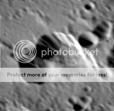
Crop & sharpened enlargement of a 100 KM wide Pit Floored Crater (possibly due to the withdrawal of magma).
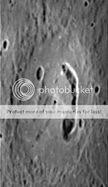
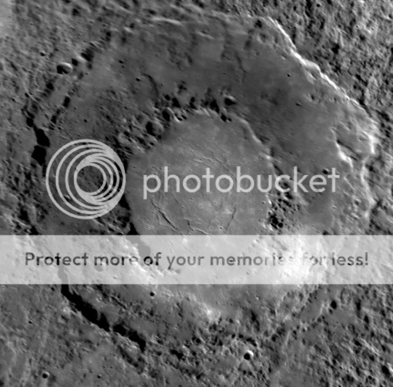
Crop & sharpened view of the newly seen 290 KM wide double ringed basin.
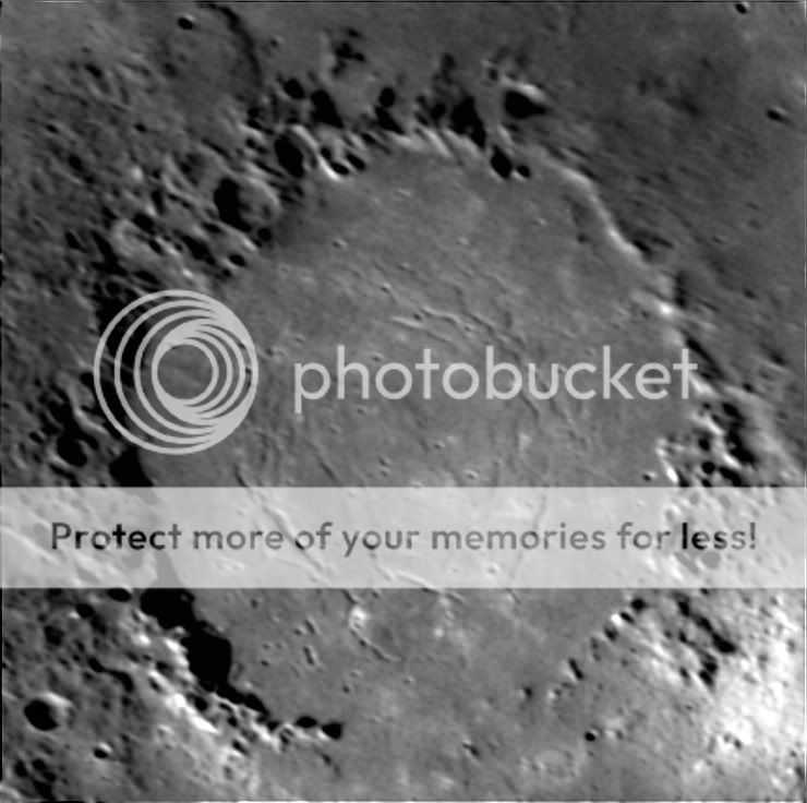
Crop & sharpened enlargement of the area within the inner ring (approx 145 KM wide) of the newly seen 290 KM wide double ringed basin. Many extentional faults are seen within the inner region.
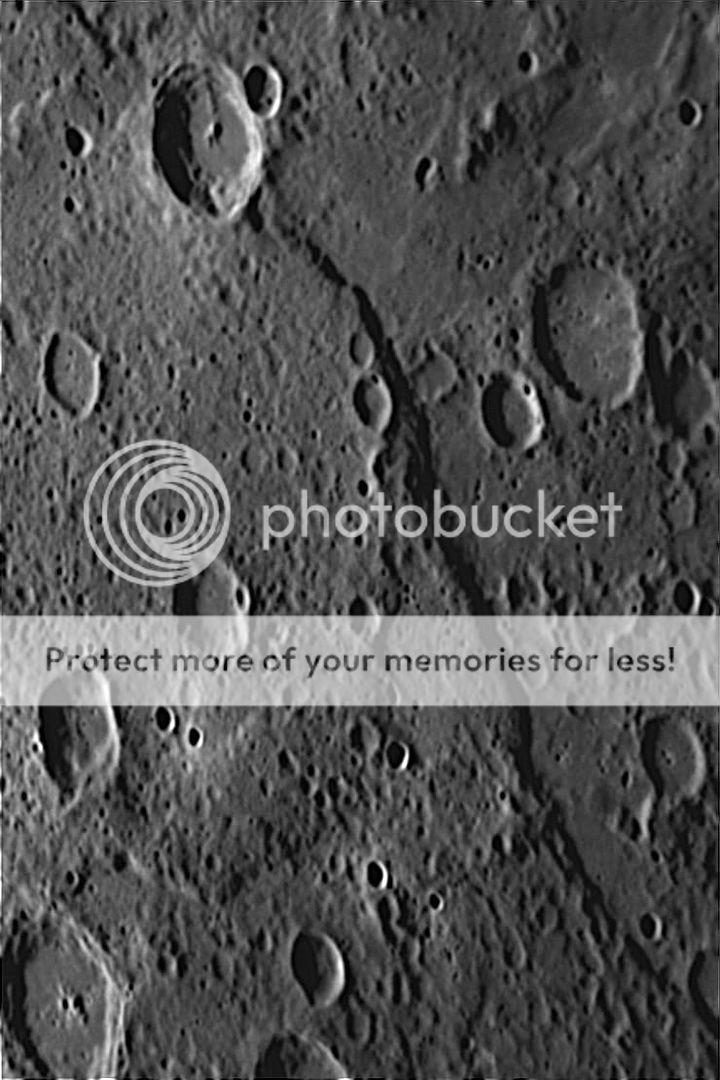
Crop & sharpened enlargement of a 100 KM long section of a newly seen Rupes on Mercury, thought to have formed when the interior of Mercury started to cool & contract, causing fractures in the crust.
Countdown to Orbital Insertion around Mercury.
407 Days.
18 Hours.
24 Minutes.
30 Seconds.
Andrew Brown.
Crop & sharpened enlargement of the suspected 30 KM wide Volcanic crater with pyroclastic deposits.

Crop & sharpened enlargement of a 100 KM wide Pit Floored Crater (possibly due to the withdrawal of magma).

Crop & sharpened view of the newly seen 290 KM wide double ringed basin.

Crop & sharpened enlargement of the area within the inner ring (approx 145 KM wide) of the newly seen 290 KM wide double ringed basin. Many extentional faults are seen within the inner region.

Crop & sharpened enlargement of a 100 KM long section of a newly seen Rupes on Mercury, thought to have formed when the interior of Mercury started to cool & contract, causing fractures in the crust.

Countdown to Orbital Insertion around Mercury.
407 Days.
18 Hours.
24 Minutes.
30 Seconds.
Andrew Brown.
3
3488
Guest
The first update for a little while.
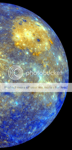
Multispectral false colour.
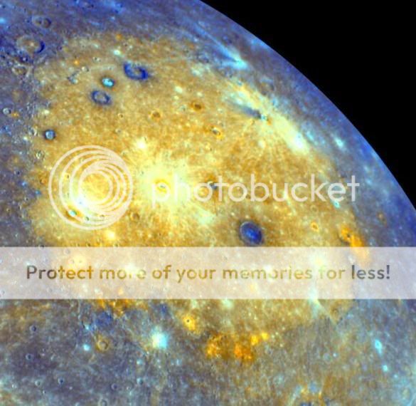
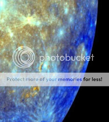
Minerological image of Mercury from Encounter #1 January 2008.
A couple of quick crops. Will be glad when I get my computer back.
Caloris Basin. The yellow denotes volcanic lava plain.
Tolstoj Basin.
Countdown to Orbital Insertion around Mercury.
393 Days.
5 Hours.
37 Minutes.
15 Seconds.
Andrew Brown.
Multispectral false colour.
Minerological image of Mercury from Encounter #1 January 2008.

A couple of quick crops. Will be glad when I get my computer back.
Caloris Basin. The yellow denotes volcanic lava plain.

Tolstoj Basin.

Countdown to Orbital Insertion around Mercury.
393 Days.
5 Hours.
37 Minutes.
15 Seconds.
Andrew Brown.
E
EarthlingX
Guest
- Status
- Not open for further replies.
Similar threads
J
- Replies
- 10
- Views
- 1K
J
J
- Replies
- 1
- Views
- 957
M
J
- Replies
- 2
- Views
- 820
J
J
- Replies
- 5
- Views
- 1K
3
TRENDING THREADS
-
Hubble Tension explained (including its value) by the two phase cosmology
- Started by Geoff Dann
- Replies: 183
-
-
New interpretation of QM, with new two-phase cosmology, solves 15 foundational problems in one go.
- Started by Geoff Dann
- Replies: 278
-
-
The birth of the Quantum Convergence Threshold (QCT):
- Started by Capanda Research
- Replies: 84
-
Basic Error: The accelerating Universe conclusion - reason
- Started by Gibsense
- Replies: 260
-

Space.com is part of Future plc, an international media group and leading digital publisher. Visit our corporate site.
© Future Publishing Limited Quay House, The Ambury, Bath BA1 1UA. All rights reserved. England and Wales company registration number 2008885.

