Mars Reconnaissance Orbiter Update Thread

Page 22 - Seeking answers about space? Join the Space community: the premier source of space exploration, innovation, and astronomy news, chronicling (and celebrating) humanity's ongoing expansion across the final frontier.
Status
Not open for further replies.
E

EarthlingX

Guest
I found something interesting here :

Candidate Landing Site over Potential Chloride Salt Deposits (ESP_016354_1745)

i cut it out from this image : http://hirise-pds.lpl.arizona.edu/PDS/E ... browse.jpg

CandidateLandingSites_2010_03_ESP_0.jpg


Could those be holes on the roof of something like a lava tube ?
 
E

EarthlingX

Guest
asunews.asu.edu : Middle-school project discovers cave skylight on Mars
They went looking for lava tubes on Mars — and found what may be a hole in the roof of a Martian cave.

skylight1.jpg

The small round black spot in this THEMIS image may be a hole in the roof of a Martian lava tube or cave.

The 16 students in Dennis Mitchell's 7th-grade science class at Evergreen Middle School in Cottonwood, Calif., chose to study lava tubes, a common volcanic feature on Earth and Mars. It was their class project for the Mars Student Imaging Program (MSIP), a component of ASU's Mars Education Program, which is run out of the Mars Space Flight Facility on the Tempe campus.
 
3

3488

Guest
Thanks EarthlingX,

Hopefully MRO will get to have a look with the HiRISE.

Almost certainly a lava tube collapse & the gigantic shield volcano Pavonis Mons certainly has many lava tubes (as have the others Ascraeus Mons & Arsia Mons) on the Tharsis Bulge as well as Olympus Mons.

Andrew Brown.
 
3

3488

Guest
Fascinating Update.

Glacial like flow on Arsia Mons Volcano.

Clickable Thumbnail of glacial flow like feature on the Arsia Mons Volcano.


Clickable Thumbnail of 3.2 KM wide section.


A tiny section only a few hundred metres wide with an obstruction in the glacial flow like feature on Arsia Mons Volcano.
ArsiaMonsobstructioninglacialflowMR.jpg


A tiny section only a few hundred metres wide with an impact crater & a pressure ridge in the glacial flow like feature on Arsia Mons Volcano.
ArsiaMonscrateringlacialflowMRO.jpg


A tiny section only a few hundred metres wide with pressure ridges in the glacial flow like feature on Arsia Mons Volcano.
ArsiaMonspressureridgesinglacialflo.jpg


A tiny section only a few hundred metres wide with a shallow circular feature in the glacial flow like feature on Arsia Mons Volcano.
ArsiaMonscircularfeatureinglacialfl.jpg


A tiny section only a few hundred metres wide with what appears to be a tiny landslide in the glacial flow like feature on Arsia Mons Volcano.
ArsiaMonslandslidefeatureinglacialf.jpg


Andrew Brown.
 
K

kg

Guest
Nice pictures!
What do they mean by "glacial like" flow? Is it possible that this isn't ice? What else could it be?
 
3

3488

Guest
Hi kg,

It seems more likely that this feature is a 'fossil' or impression left behind of a former glacier that has sublimed, though to me it looks like a glacier.

However it seems more likely that it is one that has sublimated in recent geological times leaving an impression. What would be interesting & would possibly settle this, would be a CRISM observation too, to see if it is volcanic material sculpted by ice or if it IS an actual glacier.

To me looking at the final frame I posted, there is what looks like a dust avalanche on the supposed 'glacier', though it could be a glacier covered in dust (see how quickly the MER solar arrays become dusty & the fact that the Phoenix Mars Lander parachute is no longer visible due to dust).

This feature is at the western base of the gigantic shield volcano Arsia Mons.

Andrew Brown.
 
E

EarthlingX

Guest
Nanedi Valles, Mars :

[youtube]http://www.youtube.com/watch?v=7R8XXMKzA-k[/youtube]
Kowch737
July 17, 2010

Mars Reconnaissance Orbiter
Future Mars Landing Site in Antoniadi Crater
White Rock Landform in Pollack Crater
Meanders in Nanedi Valles
Dissected Mantled Terrain
Glacier-Like Flow on Arsia Mons Flank
Interior Layered Deposits in Juventae Chasma
 
K

kg

Guest
3488":3t011sqs said:
Hi kg,
It seems more likely that this feature is a 'fossil' or impression left behind of a former glacier that has sublimed, though to me it looks like a glacier.
What what be interesting & would settle this, would be a CRISM observation too, to see if it is volcanic material sculpted by ice or if it IS an actual glacier.
Andrew Brown.

I can't begin to tell you how creepy to me the thought of a glacier sublimating away is, so much of where I live was shaped by glaciers and their melt waters! What is a CRISM observation?
 
3

3488

Guest
Hi kg,

CRISM (Compact Reconnaissance Imaging Spectrometer for Mars).

It is a camera that images the Martian Surface from orbit alongside the HiRISE from Visible to Infrared wavelengths & can determine surface composition.

The glacial flow like feature at the base of Arsia Mons would be a great target for it as well as HiRISE (images I posted).

Link Here .

Thanks EarthlingX. I remember Nanedi Vallis from the MGS MOC days when it caused so much excitement. Great to see HiRISE being pressed into action over Nanedi Vallis.

I will be back with my usual crops & enlargements later.

See what I can uncover.

Andrew Brown.
 
N

newtons_laws

Guest
Results from the CRISM instrument on the MRO indicate that the region of Nili Fossae which contains carbonate bearing rocks is a "dead ringer" for Australian rocks that contain fossil evidence of early life (stromatolites), according to this BBC report:
http://www.bbc.co.uk/news/science-environment-10790648

Although Nili Fossae was at one time on the shortlist of landing sites for the future Mars Science Laboratory Rover the report says it has since been removed as the landing site was deemed too dangerous.
 
3

3488

Guest
Thank You very much newtons_laws,

I can assure you of this, with this new information to hand regarding Nili Fossae, this WILL be a future landing site, for either a crewed or unmanned lander, as will the three unsuccessful finalists of the MSL Curiosity landing site selection.

I suspect the problem is, is the fact that the landing ellipse would be tiny & as you point out, it is difficult terrain to land on. A lander using a Mars Pathfinder / MER type airbag system may be better for this area, but even then there are no guarantees.

This site will be explored at some point, I can assure you of that.

Andrew Brown.
 
E

EarthlingX

Guest
SDC : Space Computer Hiccup Sidelines Mars Spacecraft
By SPACE.com Staff

posted: 17 September 2010
07:41 pm ET


A recurring computer glitch has once again waylaid a powerful NASA spacecraft's mission to study Mars.

The malfunction affected NASA's Mars Reconnaissance Orbiter, which put itself into precautionary "safe mode" — a sort of spacecraft hibernation — after spontaneously rebooting for unknown reasons on Sept. 15, NASA officials said in an update. Mission managers are confident they will be able to revive the orbiter and resume science operations at Mars.

MRO has normal power, fully charged batteries and safe temperatures, and its ground team has begun restoring the spacecraft to full operations, NASA officials said.
 
E

EarthlingX

Guest
[youtube]http://www.youtube.com/watch?v=y1vyR-yJ-BE[/youtube]
SpaceRip | September 28, 2010

You've got your space images from Hubble... Civil War photos by Matthew Brady... fashion snaps from Richard Avedon... and many other great photographers, including these... http://www.hongkiat.com/blog/50-great...

Then you've got one of the greatest collections of all time: the images compiled by the Hi-Rise camera aboard NASA's Mars Reconnaissance Orbiter. Here is the latest in a series of stunning images of Mars surface... in a distinctive bluish cast. From University of Arizona/NASA/JPL.
 
3

3488

Guest
MRO HiRISE view of a 700 metre by 1,100 metre sized cinder cone near the base on the southern flank of the giant Tharsis shield volcano Pavonis Mons.

I used the IAS viewer for the zoom ins. Shows how dust has covered the floor of the cinder cone & it looks as if it has been inactive for quite some considerable time, owing to the tiny impact craters on it's outer slope on the right as well as dust infill. Nice lava layering though is visible.


NASA / JPL-Caltech/University of Arizona.

Amdrew Brown.
 
E

EarthlingX

Guest
www.jpl.nasa.gov : Study Links Fresh Mars Gullies to Carbon Dioxide
October 29, 2010


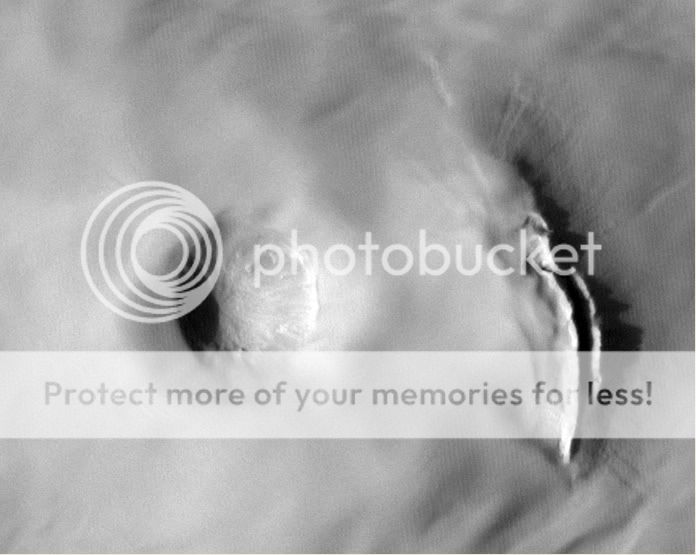
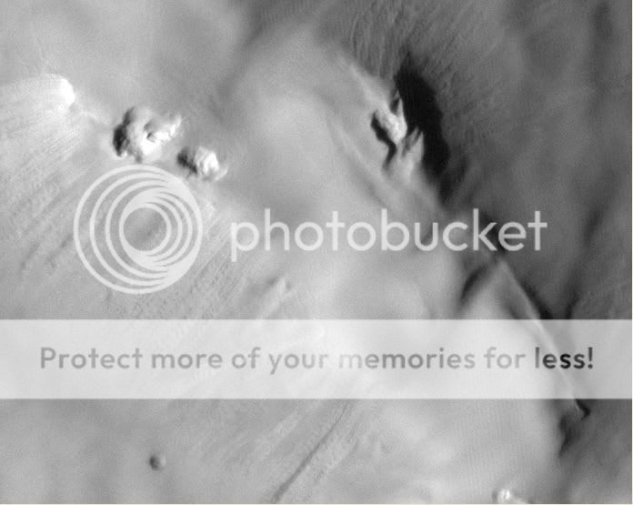
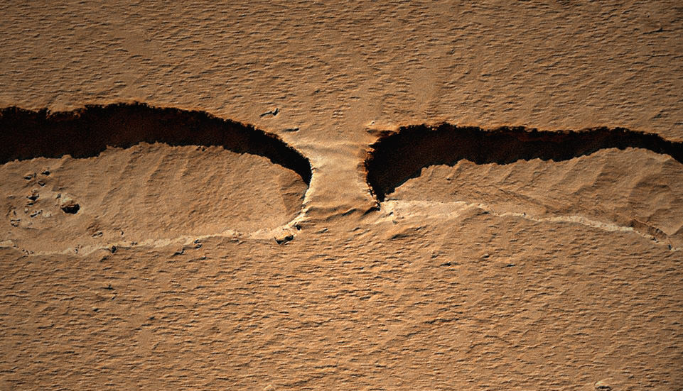
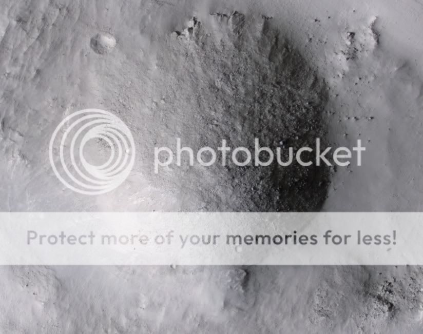
The gullies on a Martian sand dune in this trio of images from NASA's Mars Reconnaissance Orbiter deceptively resemble features on Earth that are carved by streams of water. However, these gullies likely owe their existence to entirely different geological processes apparently related to the winter buildup of carbon-dioxide frost. Image Credit: NASA/JPL-Caltech/University of Arizona

PASADENA, Calif. -- A growing bounty of images from NASA's Mars Reconnaissance Orbiter reveals that the timing of new activity in one type of the enigmatic gullies on Mars implicates carbon-dioxide frost, rather than water, as the agent causing fresh flows of sand.

Researchers have tracked changes in gullies on faces of sand dunes in seven locations on southern Mars. The periods when changes occurred, as determined by comparisons of before-and-after images, overlapped in all cases with the known winter build-up of carbon-dioxide frost on the dunes. Before-and-after pairs that covered periods only in spring, summer and autumn showed no new activity in those seasons.

"Gullies that look like this on Earth are caused by flowing water, but Mars is a different planet with its own mysteries," said Serina Diniega, lead author of a report on these findings in the November issue of the journal Geology. She analyzed these gullies while a graduate student at the University of Arizona, Tucson, and recently joined NASA's Jet Propulsion Laboratory, Pasadena. "The timing we see points to carbon dioxide, and if the mechanism is linked to carbon-dioxide frost at these dune gullies, the same could be true for other gullies on Mars."

Scientists have suggested various explanations for modern gullies on Mars since fresh-looking gullies were discovered in images from NASA's Mars Global Surveyor in 2000. Some of the proposed mechanisms involve water, some carbon dioxide, and some neither.

Some fresh gullies are on sand dunes, commonly starting at a crest. Others are on rockier slopes, such as the inner walls of craters, sometimes starting partway down the slope.

Diniega and co-authors at the University of Arizona and Johns Hopkins University Applied Physics Laboratory, Laurel, Md., focused their study on dune gullies that are shaped like rockier slope gullies, with an alcove at the top, a channel or multiple channels in the middle, and an apron at the bottom. The 18 dune gullies in which the researchers observed new activity range in size from about 50 meters or yards long to more than 3 kilometers (2 miles) long.

"The alcove is a cutout at the top," Diniega said. "Material being removed from there ends up in a fan-shaped apron below."

Because new flows in these gullies apparently occur in winter, rather than at a time when any frozen water might be most likely to melt, the new report calls for studies of how carbon dioxide, rather than water, could be involved in the flows. Some carbon dioxide from the Martian atmosphere freezes on the ground during winter and sublimates back to gaseous form as spring approaches. The dunes studied are poleward of 40 degrees south latitude.

"One possibility is that a pile of carbon-dioxide frost accumulating on a dune gets thick enough to avalanche down and drag other material with it," Diniega said. Other suggested mechanisms are that gas from sublimating frost could lubricate a flow of dry sand or erupt in puffs energetic enough to trigger slides.

At an increasing number of sites, before-and-after images have documented changes in Martian gullies. The new report uses images from the Mars Orbiter Camera on Mars Global Surveyor, which operated from 1997 to 2006, and from the High Resolution Science Imaging Experiment (HiRISE) camera and Context Camera on Mars Reconnaissance Orbiter, which has been examining Mars since 2006.

"The Mars Reconnaissance Orbiter is enabling valuable studies of seasonal changes in surface features on Mars," said Sue Smrekar of NASA's Jet Propulsion Laboratory, Pasadena, Calif., deputy project scientist for this orbiter. "One key to doing that has been the capability to point from side to side, so that priority targets can be checked more frequently than just when the spacecraft flies directly overhead. Another is the lengthening span of years covered by first Mars Global Surveyor and now this mission."

JPL, a division of the California Institute of Technology in Pasadena, manages the Mars Reconnaissance Orbiter for NASA's Science Mission Directorate in Washington. Lockheed Martin Space Systems, Denver, built the orbiter. The University of Arizona Lunar and Planetary Laboratory operates the HiRISE camera, which was built by Ball Aerospace & Technologies Corp., Boulder, Colo. Malin Space Science Systems, San Diego, built and operates the Context Camera and formerly did the same for the Mars Orbiter Camera. For more about the Mars Reconnaissance Orbiter, visit http://www.nasa.gov/mro. For more about HiRISE, visit http://hirise.lpl.arizona.edu.
...
 
E

EarthlingX

Guest
SDC : Habitable Hotspots on Mars? Volcano Vents May Be Signs
By Charles Q. Choi
SPACE.com Contributor
posted: 31 October 2010
02:01 pm ET

This story was updated at 2:29 p.m. ET.


The residue of hydrothermal vents on the flanks of a volcano on Mars could be signs of one of the most recent habitable environments on the Red Planet, researchers suggest.

Scientists investigated data gathered on the Martian volcanoes in the Syrtis Major region of the Red Planet using a powerful spectrometer on NASA's Mars Reconnaissance Orbiter. They focused specifically on deposits near the relatively young Nili Patera volcanic cone, which date back some 3.7 billion years to the Early Hesperian epoch, the beginning of the middle era of Mars' history.
...


www.jpl.nasa.gov : Silica on a Mars Volcano Tells of Wet and Cozy Past

www.universetoday.com : Ancient Hot Springs Spotted on Mars

www.physorg.com : Mars volcanic deposit tells of warm and wet environment
 
3

3488

Guest
The new medication has left me a bit zonked lately, hense me being largely absent. I think I'm getting a little better now. :mrgreen:

Thanks EarthlingX.

Very interesting, certainly there was geyser activity here too where the soluables where left behind (possibly similar to what MER A Spirit dredged up with her stuck wheel, prior to getting stuck).

Will be an interesting landing site for a potential sample return.

Below. Clickable thumbnails.

100 metre wide pits in the summit caldera of Arsia Mons. Southern pit.


Northern pit in Arsia Mons caldera.


One thing that is immediatly obvious is the amount of dust, despite the altitude. Arsia Mons stands approx 17,780 metres / 58,333' above the mean Martian Areoid.

In essence Arsia Mons, along with the other Tharsis volcanoes are almost jutting out into space (it is worth mentioning that at the Mars Areoid or on most of the surface, the atmosphere is the same density as Earth's is at 35 KM / 22 miles above sea level). So only the most powerful dust storms on Mars can transport dust into the caldera of Arsia Mons, unless most of this dust was transported here when Mars had a denser atmosphere.

This suggests that these caldera pits & possibly Arsia Mons generally has been inactive for a very, very long time.

Andrew Brown.
 
E

EarthlingX

Guest
E

EarthlingX

Guest
www.planetary.org : Fly over Mars
Nov. 8, 2010 | 10:19 PST | 18:19 UTC

By Emily Lakdawalla

Adrian Lark has posted several new flights over gorgeous Martian landscapes to his Youtube channel. My favorite of his recent ones is this dive into Zumba crater:

[youtube]http://www.youtube.com/watch?v=ftS4rujxJWo[/youtube]

But don't miss the other recently posted videos, flying around West Holden crater, Dunes in Herchel crater, and a Dune Avalanche. Adrian creates his animations from digital elevation models produced by the HiRISE camera on Mars Reconnaissance Orbiter, using a 3D engine that he wrote himself that actually generates the flythroughs in real time, just like in a video game. Here's an older video of his, of Candor Chasma.
 
E

EarthlingX

Guest
www.universetoday.com : Rock Bridge on Mars
Nov 19th, 2010

by Nancy Atkinson


A landform on Mars that looks like a naturally occuring bridge across a chasm. Credit: NASA/JPL/U of Arizona/ colorization by Stu Atkinson.

The HiRISE camera on the Mars Reconnaissance Orbiter took an image of a thin channel, and a portion of it contains a naturally occurring bridge over the chasm. Kelly Kolb from the HiRISE team says it is probably a remnant of the original surface, the rest of which has collapsed downward. It isn’t likely there’s a opening underneath the formation, but if there were, it would look very similar to a rock bridge formation found in Jordan in the Wadi Rum, the Valley of the Moon. See an image below.

Kolb also said this is unlikely to be a channel formed by a running water, as there are no obvious source or deposit regions. The channel is probably a just a collapse feature.

And see the full HiRISE image of the thin channel, found in Mars northern hemisphere between some “knobs” called Tartarus Colles, below.
...
For more information about this image on Mars, see the HiRISE website.
 
B

billslugg

Guest
Here is a landslide on the central peak of a large crater at 12.1N, 105.1E taken on 21 Dec 2008
Large Central Mountain of a Large Crater (ESP_011273_1925)
(7180,29340)

slump.jpg
 
B

billslugg

Guest
Here is an anomalous group of pixels in an image of a Gullied Trough in Noachis Terra PSP_001691_1320. I mentioned this previously in 2007 in this forum. This is a tiny portion of HiRISE image PSP_001691_1320 A Gullied Trough in Noachis Terra. I used the full image grayscale map projected image. The brightest pixel is (2558,7515) and is brightness 255 out of 256.
the surrounding area averages about 50 brightness units. Pixel size is 50 cm.

I have found a dozen or so similar bright spots in the same image, notably at (1886,13206), (2469,5873), (9175,22934).

I suspect it might be due to the passage of a heavy ion through the detector. I have looked at GOES12 proton flux data around the time the image was taken (Dec 6, 2006) but there had been no proton storms above the norm for at least a month.

Whitepixels.jpg
 
3

3488

Guest
Hi Bill,

To me, it does look like a Cosmic Ray strike on the CCD on the HiRISE.

Like the landslide on the central peak on the post before that one, very nice, great find, thank you for posting. Like the way the landslide bunched up as the leading edge stopped & the the rear of it kept coming, before stopping, forming a mound. Many boulders are clearly visible.

Andrew.
 
B

billslugg

Guest
3488":38gw33z6 said:
Hi Bill,
To me, it does look like a Cosmic Ray strike on the CCD on the HiRISE.
Andrew.

Thank you for your reply Andrew. Here is a response I got from the HiRISE team

"Yes, you are quite right that these are cosmic ray hits on the CCDs. In our
processing pipelines, we do apply filters to our imagery to detect and remove these,
but the larger the hit, the more difficult it is for our automated pipelines to
filter them out. Occasionally, even the one pixel hits get through, especially when
the data values don't rise much higher than the surrounding signal.

Incidentally, we often get emails from folks searching for the Mars Polar Lander and
mistaking hits like this as potential candidates for the lander.

Thanks for your feedback, and we hope you continue to enjoy our images."
 
Status
Not open for further replies.