LRO Lunar Reconnaissance Orbiter Mission.

Page 10 - Seeking answers about space? Join the Space community: the premier source of space exploration, innovation, and astronomy news, chronicling (and celebrating) humanity's ongoing expansion across the final frontier.
Status
Not open for further replies.
3

3488

Guest
First identified by early astronomers during the Renaissance, the Reiner Gamma formation has been a subject of intense scientific study for almost five de..........

Article here.

Reiner Gamma, 80 KM wide area shown LRO LROC WAC. Arrow points to NAC observation below
1-reinergammar.png


Reiner Gamma, 510 Metre wide area shown LRO LROC NAC.
reinergammar.png


Andrew Brown.
 
3

3488

Guest
Newly discovered cliffs in the lunar crust indicate the moon shrank in the recent past (geologically speaking) and might still be shrinking today according to a team analyzing new images from NASA's Lunar Reconnaissance Orbiter (LRO) spacecraft. The results provide important clues to the moon's rec...........

LRO captures evidence of lunar 'shrinkage'.

[youtube]http://www.youtube.com/watch?v=pHW0aOBYiMk[/youtube]

Lunar thrust faults remarkably similar to the rupes on Mercury, point to a similar origin. With the moon it amounts to only a few hundred metres, but is still a very significant discovery about our moon.

Andrew Brown.
 
M

MeteorWayne

Guest
Just FYI, Andrew, I started a thread in SS&A on this, since I thought it was significant. No problem for now in having the two threads.
 
3

3488

Guest
Thanks Wayne,

I fail to see how I missed it :eek:

I've copied the above post onto your thread & I'll use that for fututres posts on this very topic. I agree 100% with you, this is a very significant development in our understanding of the moon.

Andrew Brown.
 
J

jumpjack2

Guest
Very interesting thread. It's a pity I can't look at videos from office PC...

What about the "cavern" discovered on the moon months ago? Was it confirmed? I remember an oblique snapshot was planned, too, to look for "traditional" caverns entrances.
 
E

EarthlingX

Guest
www.planetary.org : Two natural bridges on the Moon
Sep. 7, 2010 | 11:28 PDT | 18:28 UTC

By Emily Lakdawalla

Imagine this landscape: you're walking across an unusually smooth lunar surface, an impact melt sheet on the floor of a relatively recently formed crater. Suddenly, a pit opens before you, leading to a floor six meters below you. Crossing the pit is a thin, arching bridge of solid lunar rock. Taking a chance on an unusual walk, you venture out onto the platform, which is 7 meters wide and 20 meters long -- just a short walk across, but you feel nervous about doing your usual astronaut skip, knowing there is open space passing beneath the bridge under your feet. So instead you shuffle along, raising little puffs of dust, and breathe a sigh of relief as you finish your crossing.

That scenario is now known to be possible, as the Lunar Reconnaissance Orbiter Camera team has discovered a natural bridge within one of the "Constellation Regions of Interest" within King crater, on the lunar far side.


Natural bridge on the Moon
In a first, the Lunar Reconnaissance Orbiter camera team spotted a natural bridge on the Moon in an image from King crater, on the lunar farside. The bridge appears to have formed when two adjacent sections of roof collapsed into an underground void, leaving a small section of uncollapsed roof between them. Such collapses are commonly theorized to form into lunar lava tubes, but this region is not associated with lunar volcanism; instead, the collapse appears within the impact melt sheet of King, a very fresh, moderately sized (77-kilometer-diameter) crater. Credit: NASA / GSFC / ASU

More in the article.


SDC thread about Tunnels on the Moon
 
3

3488

Guest
OMG :shock:

Thank you so very much EarthlingX.

What a spectacular update, mind you I am a volcano head!!!!!!!!

I have downloaded the images & I will return with my usual enlargements, enhancements, etc.

Andrew Brown.
 
3

3488

Guest
Collapsing Lava Tubes near the tunnel in Lunar Farside King Crater as per EarthlingX's update.

Large image, click on for gull size. I have enlarged this crop by 50% & sharpened it.


Sharpened enlarged crop of image from the EarthlingX update.
KingCraterLavaTubeenlargedcropLRO.jpg


I will be back with more. There are small cones in the area too & I will return with them tomorrow.

Andrew Brown.
 
E

EarthlingX

Guest
:mrgreen: Niiicee :cool: Very easy to see the bridge now :)

You noticed Emily asking for help in finding the second bridge in those images ? I think it is to the right and above this one, but not sure .. ? Those cracks look like collapsed lava tubes to me, are they ?

There is also update in the article with 3D images, and some other updates about availability of the rest of image set.
 
3

3488

Guest
Hi EarthlingX,

Yes indeed they are.

Lunar farside King Crater which is 76 KM wide seen in it's entirety from CM Casper Apollo 16.


LRO LROC NAC context.


Below some enlarged, sharpened crops.

750 metre wide area from LRO LROC NAC of small cones on floor of King Crater.
KingCraterfloorvolcaniccones2KMwideareaLRO.jpg


500 metre wide area with a small volcanic cone on the floor of King Crater.
KingCraterfloorvolcaniccone500metrewidearea1LRO.jpg


Another here.
KingCraterfloorvolcaniccone500metrewidearea2LRO.jpg


And here.
KingCraterfloorvolcaniccone500metrewidearea3LRO.jpg


Andrew Brown.
 
3

3488

Guest
About 10 KM to the south & east of Sulpicius Gallus is the Montes Haemus range that forms the edge of the Serenitatis basin

Sulpicius Gallus itself is a 10 KM wide relatively fresh impact crater.

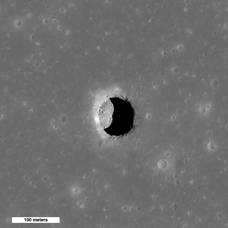
Volcanic Vent near Sulpicius Gallus.

LRO LROC NAC crops & sharpened enlargements by me of a stongly suspected, almost confirmed volcano on the Moon.

Apollo 17 CM America in December 1972 first noticed the vent near Sulpicius Gallus, a possible lunar volcano.

Also the fact that pyroclasts did not appear to be too intensively space weathered into the native launer regolith by micrometeroids also suggested that the vent near Sulpicius Gallus may not have been just an extnct relic from the early days of the Moon's evolution, perhaps evidence for more 'recent' volcanism on the Moon?????

Clementine a DOD test spacecraft to test new remote sensing instrumentation for the military was pressed into civilian scientific research as a caveat from the Peace Dividend, the USAF operated the spacecraft & carried out the instrument testing & civilian NASA scientists researched the information. Clementine was to have gone onto to an Near Earth Asteroid 1650 Geographos close encounter, but unfortunately a serious software fault fired the motors up & the craft ran out of fuel after leaving selenecentric orbit.

However the Lunar orbital mission was an enormous success. Clementine showed very clear pyroclastic signatures at the vent near Sulpicius Gallus.

When LRO was planned vent near Sulpicius Gallus was considered an extremely high priority for LRO, both NAC & WAC of LROC as well as full multispectral observations.

Clickable thumbnail of LROC WAC of area of interest.


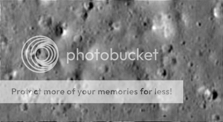
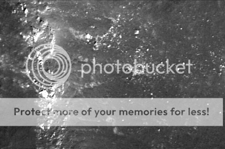
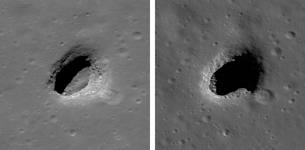
LRO LROC NAC 517 metre wide section of inner slope of Sulipicius Gallus vent. Layered volcanic bedrock, alternating compressed ash & lava. Vocanic glass beads like the 'Orange Soil' found by Apollo 17 appear to be abundant in this area.
517metrewidesectionofvolcanicventSulpiciusGallusLRO.png


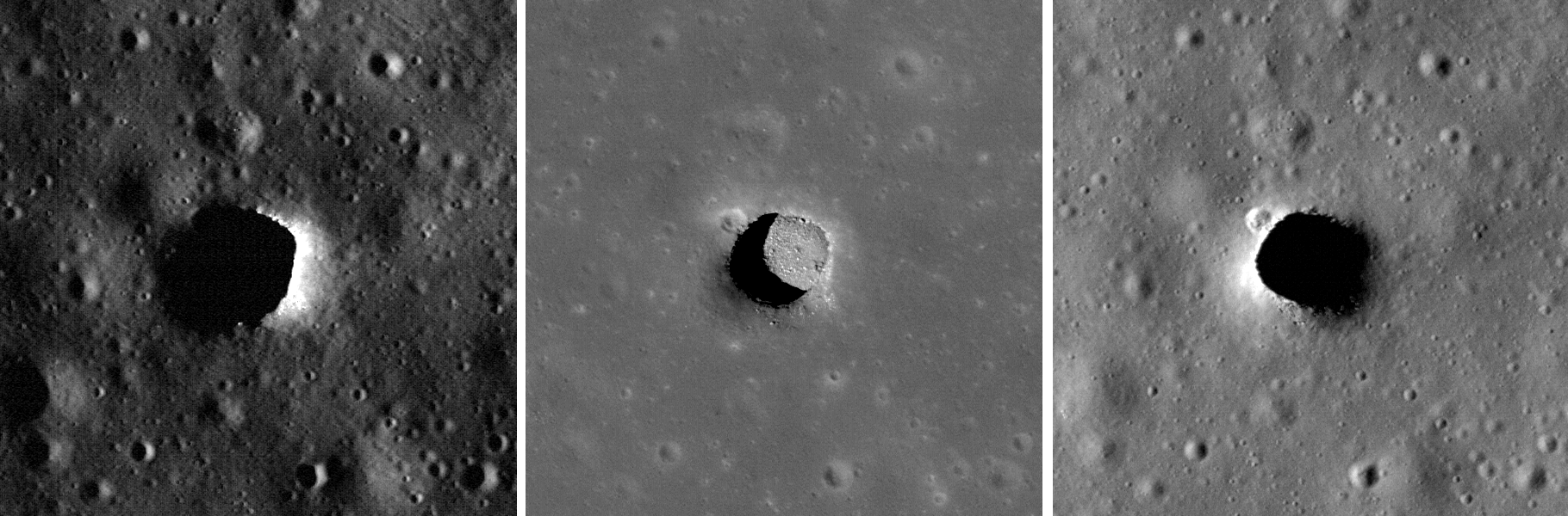
LROC NAC crops & sharpened enlargements by me.

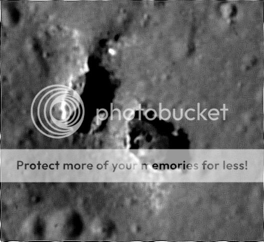
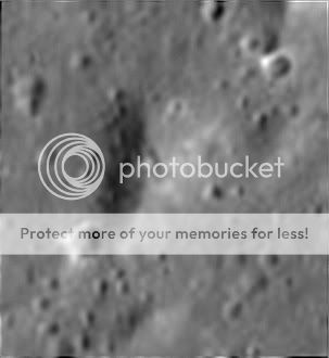
1.3 KM wide area. Volcanic crater / vent near Sulpicius Gallus on right with darkened ash rich regolith outside.
13KMwideareawithvolcanicventSulpiciusGallusLRO.jpg


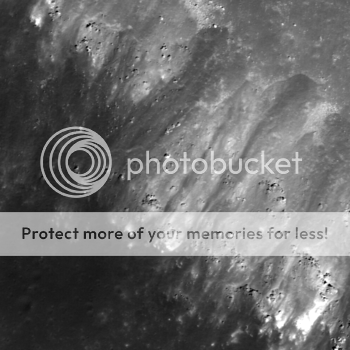
700 metre wide area of rim & floor of the volcanic vent. Flat floor with boulders rolled in from the rim.
600metrewideareaofvolcanicventSulpiciusGallusLRO.jpg


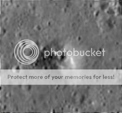
650 metre wide area showing an even darker patch of pyroclasts.
650metrewideareanearvolcanicventSulpiciusGallusLRO.jpg


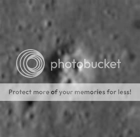
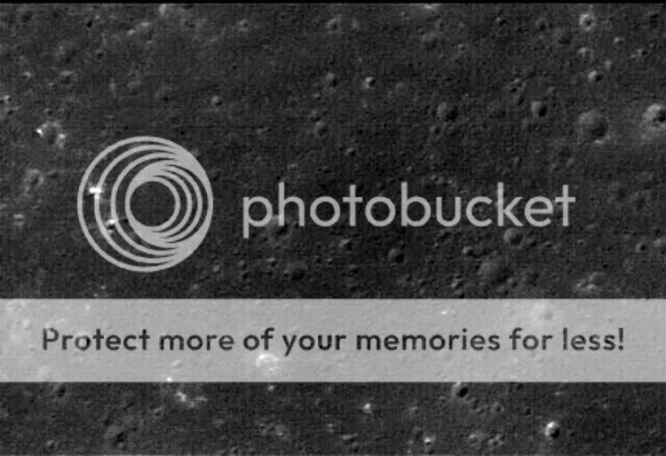
450 metre wide impact crater approx 3 KM to the SW of the vent. The impact exposed some layered lava.
450metrewideimpactcraternearvolcanicventSulpiciusGallusLRO.jpg


Andrew Brown.
 
E

EarthlingX

Guest
lroc.sese.asu.edu : New Views of Lunar Pits
Posted by Mark Robinson

14th Sep


Spectacular high Sun view of the Mare Tranquillitatis pit crater revealing boulders on an otherwise smooth floor. Image is 400 meters wide, north is up, NAC M126710873R [NASA/GSFC/Arizona State University].


Two views of Mare Ingenii pit [NASA/GSFC/Arizona State University].


Variations in lighting reveal the structure of the fascinating lunar pit craters. The center panel, with the Sun high above, gives scientists a great view of the Maurius Hills pit floor. Each panel is 300 meters wide, left M133207316LE, center M122584310LE, right M114328462RE [NASA/GSFC/Arizona State University].

More in the article.
 
E

EarthlingX

Guest
SDC : NASA's Lunar Reconnaissance Orbiter Gets New Moon Mission
By SPACE.com Staff

posted: 16 September 2010
12:07 pm ET


NASA's latest lunar probe has wrapped up the exploration phase of its moon-watching mission and is shifting into pure science gear to help scientists better understand Earth's nearest neighbor.

Until now, the powerful Lunar Reconnaissance Orbiter had been scouting the moon to help NASA plan for future lunar exploration missions.

"LRO has been an outstanding success. The spacecraft has performed brilliantly," said Doug Cooke, associate administrator of NASA's exploration systems mission directorate, in a statement. "LRO's science and engineering teams achieved all of the mission's objectives, and the incredible data LRO gathered will provide discoveries about the moon for years to come."
 
M

MeteorWayne

Guest
Orientale Basin: (WOW!)

482360main_v_03_james_head_sm1.jpg


A lunar topographic map showing the Orientale basin (930 km diameter), the largest young impact basin on the Moon. This young basin formed from a projectile that impacted the Moon about 3.8 billion years ago, and penetrated deeply into the lunar crust, ejecting millions of cubic kilometers of material into the surrounding areas. The topography is derived from over 2.4 billion shots made by the Lunar Orbiter Laser Altimeter (LOLA) instrument on board the NASA Lunar Reconnaissance Orbiter. These large basins show the effects of such impacts on early planetary crusts in the inner solar system, including the Earth. Credit: NASA/Goddard/MIT/Brown
 
M

MeteorWayne

Guest
Today's teleconference marked the transition from the 1 year exploration mission (for future missions including manned) to the 2 year science mission.

These early science results will be published, fittingly, in the Science journal. Probably in the one published today...

All the images are available here:

http://www.nasa.gov/mission_pages/LRO/n ... 00916.html
 
M

MeteorWayne

Guest
482359main_v_02_james_head_sm1.jpg


A lunar topographic map showing one of the most densely cratered regions on the Moon. The topography is derived from over 2.4 billion shots made by the Lunar Orbiter Laser Altimeter (LOLA) instrument on board the NASA Lunar Reconnaissance Orbiter. These most heavily cratered areas are among the best candidates to study and explore to understand the earliest lunar history. Credit: NASA/Goddard/MIT/Brown
 
M

MeteorWayne

Guest
482361main_v_04_james_head_sm1.jpg


A lunar topographic map showing the Moon from the vantage point of the eastern limb. On the left side of the Moon seen in this view is part of the familiar part of the Moon observed from Earth (the eastern part of the nearside). In the middle left-most part of the globe is Mare Tranquillitatis (light blue) the site of the Apollo 11 landing, and above this an oval-appearing region (Mare Serenitatis; dark blue) the site of the Apollo 17 landing. Most of the dark blue areas are lunar maria, low lying regions composed of volcanic lava flows that formed after the heavily cratered lunar highlands (and are thus much less cratered). The topography is derived from over 2.4 billion shots made by the Lunar Orbiter Laser Altimeter (LOLA) instrument on board the NASA Lunar Reconnaissance Orbiter. The large near-circular basins show the effects of the early impacts on early planetary crusts in the inner solar system, including the Earth. Credit: NASA/Goddard/MIT/Brown
 
M

MeteorWayne

Guest
482362main_v_05_james_head_sm1.jpg


A lunar topographic map showing the Moon from the vantage point of the eastern limb. In this view, the yellow circles represent some of the 5185 craters equal to or greater than 20 km found on the Moon and counted in this study. On the left side of the Moon seen in this view is part of the familiar part of the Moon observed from Earth (the eastern part of the nearside). In the middle left-most part of the globe is Mare Tranquillitatis (light blue) the site of the Apollo 11 landing, and above this an oval-appearing region (Mare Serenitatis; dark blue) the site of the Apollo 17 landing. Most of the dark blue areas are lunar maria, low lying regions composed of volcanic lava flows that formed after the heavily cratered lunar highlands (and are thus much less cratered). The topography is derived from over 2.4 billion shots made by the Lunar Orbiter Laser Altimeter (LOLA) instrument on board the NASA Lunar Reconnaissance Orbiter. The large near-circular basins (large yellow circles) show the effects of the early impacts on early planetary crusts in the inner solar system, including the Earth. Credit: NASA/Goddard/MIT/Brown
 
M

MeteorWayne

Guest
6.3 MB .mov


Using the Lunar Reconnaissance Orbiter’s Lunar Orbiter Laser Altimeter (LOLA), NASA scientists have created the first-ever comprehensive catalog of large craters on the moon. In this animation, created with LOLA elevation data, lunar craters larger than 20km in diameter "light up." Credit: NASA/Goddard/MIT/Brown
 
M

MeteorWayne

Guest
A confirmed lunar volcano:

482364main_v_07_t_glotch_hansteen_sm1.jpg


Diviner data superimposed on a Lunar Orbiter IV mosaic of Hansteen Alpha, which is believed to be a silicic volcano." Red and orange colors indicate highly silicic compositions. Credit: NASA/Godard/UCLA/Stony Brook
 
M

MeteorWayne

Guest
Volcanic silicates excavated by an impact:

482365main_v_08_t_glotch_aristarchus_sm1.jpg


Diviner data superimposed on a Lunar Orbiter IV mosaic of Aristarchus crater. Red and orange colors indicate highly silicic compositions. Credit: NASA/Godard/UCLA/Stony Brook
 
Status
Not open for further replies.