LRO Lunar Reconnaissance Orbiter Mission.

Page 11 - Seeking answers about space? Join the Space community: the premier source of space exploration, innovation, and astronomy news, chronicling (and celebrating) humanity's ongoing expansion across the final frontier.
Status
Not open for further replies.
3

3488

Guest
Thank You very much to both Wayne & EarthlingX.

Great press briefing by the looks of it with fascinating updates.

Like this one too, the Diviner Global Composition.

Earth from LRO LROC NAC from Selenecentric Orbit on Monday 9th August 2010. This time the Americas are shown. Image back in June was centred over Asia.


I am rather tired tonight, but I intend to come back tomorrow with my usual image enlargements & my spam.


Andrew Brown.
 
E

EarthlingX

Guest
[youtube]http://www.youtube.com/watch?v=hhSkRIj6wyQ[/youtube]
NASAexplorer | September 16, 2010

Using the Lunar Reconnaissance Orbiter's Lunar Orbiter Laser Altimeter (LOLA), NASA scientists have created the first-ever comprehensive catalog of large craters on the moon. In this animation, lunar craters larger than 20km in diameter "light up" using LOLA elevation data. Craters light up in an east to west (Tranquillitatis toward Orientale) sweep around the Moon.

[youtube]http://www.youtube.com/watch?v=SC1PSGugtXA[/youtube]
NASAtelevision | September 16, 2010

New results from NASA's Lunar Reconnaissance Orbiter (LRO) spacecraft describe a Moon bombarded by two different populations of asteroids or comets in its youth, and a lunar surface more complex than previously thought.


http://www.newscientist.com : Crater map rekindles debate over moon impacts
01:02 17 September 2010

by Maggie McKee

A new map of lunar craters by NASA's Lunar Reconnaissance Orbiter is stoking a long-smouldering debate about whether the moon was hit by a sudden barrage of impactors early in its life.

The moon is thought to have formed about 4.5 billion years ago, from the debris of a collision between Earth and a Mars-sized body. Its pockmarked surface records a lifetime of impacts, the rate of which, researchers agree, has fallen over time.

At issue is whether there was a sudden spike of impacts 3.9 billion years ago, and if so, what caused it. The evidence for this "late heavy bombardment" comes from rocks collected by Apollo astronauts at several lunar sites, many of which appear to have been melted by impacts at around that time.

A 2005 study led by Robert Strom at the University of Arizona in Tucson suggested these early impactors came from a different source than what hit the moon afterwards. The researchers found a larger proportion of big craters in the moon's oldest "highlands" areas compared to those in younger areas of solidified lava.

New observations by NASA's Lunar Reconnaissance Orbiter bolster the conclusions of Strom's group. LRO measured the moon's topography by bouncing laser light off the lunar surface and calculating the time it took for the light to return.

But Gerhard Neukum of the Free University of Berlin in Germany disagrees. He thinks the differences in the distribution of crater sizes may instead be due to local surface processes that can cover up craters, such as lava flows and ejected debris from impacts.

These processes did not happen evenly across the moon. Regions paved over by lava, for example, differ in how much lava flowed over them and how often the flows occurred, he says. This would cover up underlying craters in complicated ways, making it impossible to equate the size distribution of craters with the size distribution of impactors. "Don't take [the crater counts] at face value. You have to apply corrections," he told New Scientist.

He says the reason that Apollo samples all show evidence of impacts at around the same time is because the Apollo sites lie near a giant impact basin called Imbrium, which formed about 3.9 billion years ago and blanketed surrounding areas with impact debris.

To test the late heavy bombardment theory, "we need to have absolute dates on important events", says Jay Melosh of Purdue University in Indiana.

A sudden spike of impacts 3.9 billion years ago would have been so violent that it would have left no large parts of the moon intact. "There would be no older basin, no older structure on the moon that you could still see," says Neukum.

...
 
M

MeteorWayne

Guest
E

EarthlingX

Guest
http://www.universetoday.com : The Moon’s South Pole as You’ve Never Seen it Before
Sep 28th 2010

by Nancy Atkinson


LROC Wide Angle Camera (WAC) mosaic of the lunar South Pole region, width ~600 km. Credit: NASA/GSFC/Arizona State University.

The lunar South Pole – a land of craters, shadows, intrigue and science! This wide-angle mosaic of the South Pole is one of the latest stunning images from the Lunar Reconnaissance Oribiter. The South Pole is the home of Cabeus Crater, where LCROSS impacted in 2009, as well as the Aitken Basin, which contains impact melt that will allow scientists to unambiguously determine the basin’s age, plus Shackleton crater, the region touted as the perfect place for future outposts and huge telescopes. The permanently shadowed regions in this crater wonderland could harbor reservoirs of ice and other volatiles contain a “priceless record of water composition dating back to the beginning of our Solar System, an incomparable dataset for astrobiology investigations,” said Mark Robinson, principal investigator for the Lunar Reconnaissance Orbiter Camera. “Additionally, these volatile deposits could serve as a tremendously valuable resource for future explorers.”
...
Stay tuned!

Source: LROC website
 
3

3488

Guest
WOW amazing EarthlingX.

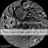
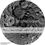
A nice compliment to your excellent post, the Moon's North Polar region from LRO.

Clickable Thumbnail. 600 KM wide. Outer rim 80 North to the North Pole on the Moon in the centre.
LRO LROC WAC Lunar Arctic Mosaic.

Summer-time at the lunar north pole captured by the LROC Wide Angle Camera (WAC), width 600 km, latitude ranges from 80°N to 90°N [NASA/GSFC/Arizona State University]. Unlabled (left) & labled (right).


Fascinating article below.

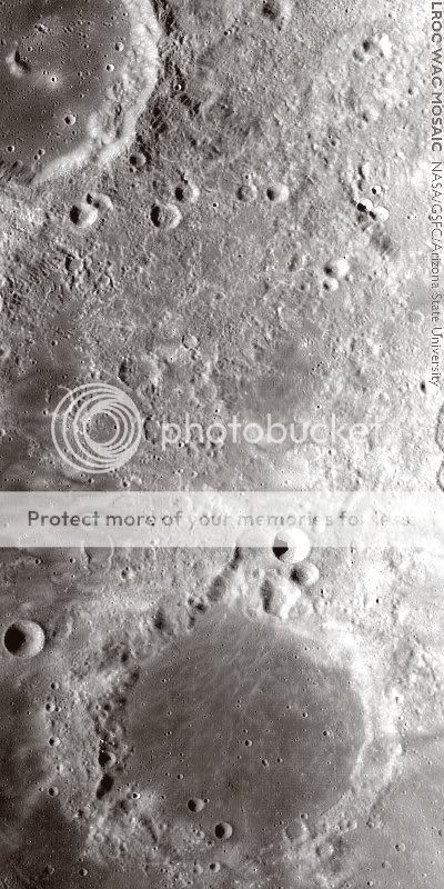
The swirls determined by the LRO MINI RF (Miniature Radio Frequency) are only at most 10 centimetres thick. Seismic waves from the Orientale forming impact focussed 180 degrees away on the other side of the Moon. On the planet Mercury, some very hilly terrain formed antipode to Caloris, this is a similar type occurance, but with a very different outcome. On Mercury, hills formed, on the Moon a curious swirled terrain formed with magnetic anomalies.

Antipode to Mare Orientale.

CM119279428-1-ME_643nm_MSICE-stitch-400x800AntipodetoMareOrientaleLRO.jpg

Orientale Antipodes - Goddard - the Grand Swirl field on the direct opposite side of the Moon from Mare Orientale. The broad area is coincident with crustal magnetism. LROC WAC (false color) Mosaic (689nm) from LRO orbits 4445-4450, June 13, 2010; avg. alt. 51.653 km, avg. res. 73.04 m [NASA/GSFC/Arizona State University].

NASA/GSFC/ASU.

Andrew Brown.
 
Status
Not open for further replies.

TRENDING THREADS

Latest posts